
Haputo (Haputu)
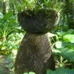
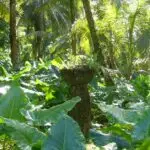
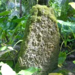
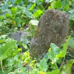
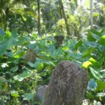
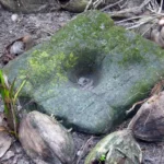
Table of Contents
Share This
Ancient village on Guam's northwestern coast
Haputo is located on military-owned land on the northwestern coast of Guam, near the Naval Communications Station (NCTAMS) in Finegayan. It is protected by the US Navy as the Haputo Ecological Reserve. The pristine, secluded beach is accessible by a hiking trail that includes 212 narrow man-made steps that descend about 100 feet down a fairly steep incline to crystal blue waters. Nearby are the remains of an ancient CHamoru/Chamorro village. Guam residents may access the beach with a military identification card or with special military authorization.
Haputo was designated an ecological reserve in 1984, covering 252 acres of coral reef and limestone forest. The area was declared a preserve to protect it from the negative impacts of human activities and the introduction of invasive species. Haputo is also listed in the Guam and National Registers of Historic Places.
Historical background
As with many other ancient sites on Guam, not much is known about the history of Haputo. Historic accounts from the early Spanish era mention that the village of Haputo (sometimes spelled Apoto) was burned in 1678 by Spanish soldiers as the newly appointed Governor Captain Juan Antonio Ruíz de Salas tried to make his way to Tarague on the northeast coast to inflict punishment on the rebellious villagers there. Unable to get to Tarague because of the dense vegetation, he passed through Haputo on his way back to Hagåtña and burned several houses. The soldiers are believed to have passed very close to the latte set located in what is now Latte Stone Park in South Finegayan.
Aguarin, (sometimes spelled Agualin) a Chamorro warrior chief who led an uprising in Hagåtña in 1677 had lived in Haputo in 1678. Another chief of Haputo named Ayihi (who adopted the name Antonio when he converted to Christianity) was one of a group of Chamorro leaders who sided with the Spanish in the early years of the Chamorro-Spanish wars. In 1680 as the Spanish tightened their hold on the Mariana Islands, the surviving residents of Haputo and all the other northern villages of Guam, were forced to relocate to Hagåtña as part of the reducción led by Jose de Quiroga y Losada.
Although the village was abandoned, it still was recognized by name and located on early European maps of Guam. French explorer Louis Freycinet wrote in 1819 that Haputo was one of two sites where Carolinian canoes landed–the first to land on Guam since the arrival and takeover of the Marianas by the Spanish. The canoes arrived on 19 June 1712 from the island of Farroilep (now spelled Falalop) after having been blown off course by a storm. (Incidentally, a Jesuit missionary on Guam at the time named Padre Juan Antonio Cantova was so intrigued by these visitors that he was compelled to try and find their home islands in 1722 to set up a mission. He was unable to locate the island and later made a second attempt in 1731 only to be killed at Mogmog, near the island of Falalop in Ulithi Atoll, Yap State Federated States of Micronesia, becoming the first martyr in the Caroline Islands).
In the early 1800s, the government allowed several residents of Hagåtña to clear land for cattle grazing in the northern plateau. However, the land remained mostly unoccupied except for a few houses, and the traditional road that ran near the rugged coastline. In 1833, Captain Francisco de Villalobos traveled to the Haputo area while conducting a survey of the island to determine its military readiness. With the assistance of a guide, he presumably made his way using the traditional trail that was thickly overgrown, located along the coastal terrace from Pugua Point (just north of Haputo). According to archeologists who studied the area in 2000, the trail likely ascended upward from Ague Point up into the Finegayan plateau, then back down to Hilaʼan (which is south of Haputo). The need for a guide and the state of the overgrown trails indicated that the Finegayan area and the coast were likely not inhabited or being utilized.
The early 1900s also saw little use of the northern part of Guam near Finagayan, except for the growing of coconut trees for the copra trade. Even the Japanese forces during the World War II occupation of Guam seemed to have little use for the area, focusing their activities in their headquarters in Yigo to the east. However, the Pugua site has a cave that was used by US Navy radioman George Tweed as one of several hideouts to evade capture by the Japanese during the war.
By 1951, the Navy Communications Station was established in the Finegayan area and development of the facility included the building of three large complexes of directional antennae. A housing complex was constructed in the 1950s or early 1960s, but was eventually dismantled after the extensive damage from Typhoon Paka in 1997. The Haputo area has remained undeveloped except as a recreational and fishing site. The area was eventually restricted to military personnel and visitors with special authorization.
Early archeological research
Archeologically, Haputo resembles other coastal settlements found in the largely limestone landscape of the northern part of Guam. The village site was visited in 1947 by Navy archeologist Douglas Osborne, who had also conducted archeological surveys throughout the island, including Fena and Pulantat in south-central Guam, and in different sites along Tumon Bay. According to Osborne, the remains at Haputo resembled Gongna, the area next to the current location of the Nikko Hotel on the north end of Tumon Bay. Gongna was a heavily used ancient site but was greatly disturbed by military construction in the area to create a recreational space for military personnel. Unlike Gogna, though, Haputo was undisturbed and less extensive. The beach and cove of Haputo were far more difficult to access, but even Osborne was taken by the natural beauty of the place. The surrounding jungle vegetation was thick, with an abundance of pupulu diablo (Piper guahamenes), an indigenous shrub used by local healers to make herbal remedies.
Osborne reported five groups of latte of eight stones each, medium in size, and located back from the waterʼs edge, closer to the base of the cliff. The latte had a general north to south orientation, making them parallel to the cliffs and ocean. The haligi or bases were composed of coralline limestone and the taza or capstones were made of hemispheres of brain coral. Individual stones were in rows spaced about nine feet apart. The latte in one of the groups measured about 5ʼ6” tall. One of the latte was upright with its capstone set in place.
Osborne also observed an abundance of pottery sherds of various tempers, but mostly clay and sand. The average thickness for the sherds with sand tempering was about 0.35 inches, with only a small few above 0.40 inches or below 0.35. Some sherds exhibited a rough combing pattern on the outer surface. The few fragments Osborne noted of clay temper were thin and plain surfaced. He reported evidence of a “definite trend toward the use of sand temper” over time.
The Haputo area was later revisited by National Park Service archeologist Erik Reed in 1952, and by Micronesian Area Research Center (MARC) archeologist Fred Reinman in the mid-1960s. Reinman described that access to the area was difficult and required walking along a steep and slippery trail. Because of its limited accessibility, the area was still in a relatively undisturbed state since Osborneʼs visit almost 20 years earlier. The midden of archeological remains began about 25 to 30 meters back from the water and extended all the way to the back of the limestone cliff line. The most heavily concentrated remains were associated with latte sets. Pottery, tools made of stone and shell, lusong (or mortar stones) were found, along with an abundance of seashells. Reinman noted the upright latte reported by Osborne no longer had its capstone in place. However there are still latte with capstones at Haputo. The thick vegetation included coconut and federico palms, papaya trees and bamboo, along with taro and alocasia plants (elephant ears).
On the north side of Haputo Beach is Haputo Point. Reinman reported a number of rock shelter caves and overhangs which contained an abundance of pottery and other debris. The eroded limestone ends at the water in a low ledge around five to ten meters high. The amount of debris seemed to indicate the area had been heavily occupied in the past.
Recent archeological research
In the spring of 2000, researchers from the Micronesian Archaeological Research Services and International Archaeological Research Institute, Inc., conducted a survey of surplus Navy lands, including a stretch of land in the Finegayan area, from the coastline and through the limestone plateau, up to Route 3 or NCS Road. The ancient site of Haputo was just outside the area of study to the north. However, nearby Ague Cove was extensively studied.
The Finegayan area covers about 3500 acres and is divided into North Finegayan, which extends 2900 acres, and South Finegayan, which is only 712 acres. The two are separated by a stretch of land once controlled by the Federal Aviation Administration (FAA), which was the focus of the study. Finegayan lies on the northern limestone plateau, but extends seaward creating a tall cliff line that is indented in two places, forming small coves or larger reef flats. The limestone forest contains primarily evergreen plants and scrub that grow well in salty environments. The flat coastal strip at cliff base has an abundance of coconut plants.
The researchers found that prehistoric settlement of the Finagayan area was concentrated on the coast, including Haputo, which was considered a primary settlement site, along with Pugua and Hilaʼan. A fresh water well at Haputo made it possible to sustain a viable population. Archeologists believe Haputo was occupied almost 2000 years ago–ceramics from the area date in the range of 100 to 400 AD. Changes in the sea level would have allowed people to occupy rock shelters along the area, if only intermittently, during the pre-Latte period. The earliest pre-Latte pottery also seem to suggest–by their composite materials that come from different places–that their makers/users traveled considerably between islands. Later Latte era (about 1000 AD) pottery lacks some of the materials found in older ceramics, perhaps reflecting more restricted movement compared with earlier times.
The Haputo settlement had at least 23 latte stone sets, distributed in a semi-circular patter, following the curve of the bay. The site appeared to have been permanently occupied, with fresh water available year round, and an abundance of marine and reef resources. Also, plants in the nearby jungles provided building materials as well as food resources. The cliff face also provided shelter from storms, and, with gentle ocean breezes, a pleasant, cool environment for the siteʼs inhabitants.
North of Haputo is an area called Pugua, which has a rock shelter that contains pictographs. Although Osborne had reported this site had a latte set it was not relocated in the 2000 archeological survey. Another interesting feature of this area is a sinkhole that leads to a chambered cave with a fresh water pool. The walls of the chamber are slick limestone, but has impressions of hand and footholds to access the pool–the first observed case of such prehistoric construction to reach water.
Further south along the coast but outside Navy property is Hilaʼan, located on a large coastal flat north of Tanguisson Point. Hilaʼan has 20 latte sets, numerous caves and rock shelters, two wells and a fresh water pond. There is also evidence of latte period occupation at Ague Cove located just outside the southern border of North Finegayan.
The limestone forest further inland in the Finegayan area shows little evidence of permanent habitation. Few megalithic structures have been found, except for the latte set that is located at the Latte Stone Park. The set includes ten coral pillars, one of which shows damage from World War II, and associated capstones and artifact scatters. Isolated mortars have also been found in Finegayan.
It is believed the ancient Chamorro inhabitants residing in Haputo or even Hilaʼan may have used this upland area for food collecting, gathering and perhaps some dry land farming. Rice could possibly have been grown, but other staples like taro seem more plausible as a preferred food source. The latte set may indicate considerable residential use, although it is more likely, based on traditional patterns seen elsewhere on Guam, that main residences were along the coast. It is also likely that more sets may have existed but were destroyed over time and with development of the area since World War II.
Today large sections of the northern plateau have been developed and are now populated. The jungle limestone forests now include additional plant species, especially tangentangen. But the importance of Haputo and the other sites along the stretch of coast on northwest Guam provide insight into what life might have been like for some of the earliest inhabitants on Guam. Haputo as a heritage site is rich with cultural resources. It is a breathtaking area that few have privilege and opportunity to visit, but those who are able to see Haputo often exclaim it has one of the most beautiful beaches on the island.
For further reading
Carson, Mike T., ed. “Archaeological Studies of the Latte Period.” Micronesica 42, no. 1/2 (2012): 1-79.
Osborne, Douglas. “Archaeology on Guam: A Progress Report.” American Anthropologist 49, no. 3 (1947): 518-524.
Reinman, Fred. An Archaeological Survey and Preliminary Test Excavations on the Island of Guam, Mariana Islands, 1965-1966. Mangilao: Micronesian Area Research Center, University of Guam, 1977.
Thompson, Laura M. Archaeology of the Mariana Islands. Bernice P. Bishop Museum Bulletin, No. 100. Honolulu: Bishop Museum Press, 1932.
–––. Guam and Its People. With a Village Journal by Jesus C. Barcinas. 3rd ed. New Jersey: Princeton University Press, 1947.
US Department of the Interior National Park Service. General Report on Archeology and History of Guam. By Erik K. Reed. Sante Fe: NPS, 1952.