
Ancient CHamoru/Chamorro Fish Weirs (Gigao)

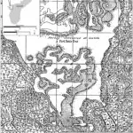
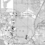
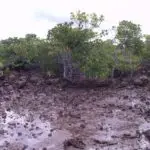

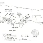
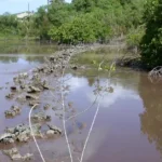
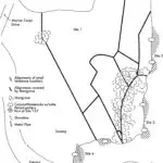
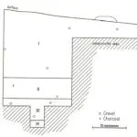
Table of Contents
Share This
Salt-water fish traps
When French explorer Louis Claude de Freycinet visited Guam between March and June of 1819, he observed CHamorus/Chamorros capturing mañåhak or juvenile rabbitfish (Siganus spp.) in gigao or fish traps placed in shallow tidal waters north of Cabras Island and near the mouth of the Masso River.
He described the fish weir as constructed of wickerwork framing or fencing and strengthened by stakes or laths, with smaller pools divided into two or three sections. The overall shape of the weir was triangular, enabling the fish to enter through multiple channels before being funneled into the narrowing back of the trap where they could not escape. Fish were then removed from the trap by a lagua pula, a finely meshed net.
When asked about the history of this method of fishing, Freycinet was told that gigao were formerly built of dry stones along the coast, but they had been replaced by mud barriers or reed dikes.
Remnants found at inner Apra Harbor
In 1998, archeologists discovered what they believe to be these ancient fish traps.
They found a series of low walls on the coral shelf and within the low tide area of inner Apra Harbor, near fresh water seeps situated between the mouths of the Laguas and Sasa Rivers now on US Navy property.
The archeologists discovered 14 walled pools, together measuring a total of 6,612 square meters, with individual pools ranging from an average of 321 to 551 square meters in size. The pool walls were composed of irregularly shaped, medium to large brain coral heads, piled directly on the tidally inundated coral outcrop without the aid of mortar or fill. While some stacking was evident, the walls were very porous. Today the pool areas are covered with mangroves.
The outer walls of the rectangular shaped pools measured approximately three meters wide and were no higher than one meter tall, while some of the inner walls were smaller. None of the walls reached the present shoreline, so at high tide water lapped around them.
In 2002, archeologists recorded another complex of seven walled pools near the mouth of a small estuary within the US Navy Main Base. In this site, limestone blocks as well as coral heads were used as construction materials, to create an area covering approximately 12,266 square meters, with individual beds ranging in size from 822 to 4,500 square meters in size.
Muddy sedimentation nearly covered some of the low walls due to the historic construction of Marine Corps Drive built after World War II which has restricted tidal flow in and out of the small estuary.
In both cases, small mounds located in and around coconut trees along the shoreline sometimes contained fragments of Latte Period pottery and marine shell bivalves or gastropods on the surface, although manual excavations rarely encountered artifacts deeper than 75 centimeters below the surface, with plenty of evidence of modern crab burrows.
No burials or intact latte sets were noted on this shoreline, although disturbances due to World War II and the Cold War were evident. Also present on the surface were Japanese beer and condiment bottles and piles of modern marine shells, indicating that Japanese soldiers and/or local civilians involved in building the nearby defensive bunkers likely used the ancient gigao and tidal flats to collect food, perhaps a quick lunch, during 1943 or 1944.
Are these the Gigao mentioned to de Freycinet in 1819?
De Freycinet visited Guam almost five generations after the reducción ended in 1698, when the Spanish military forcibly rounded up all CHamoru residents of the northern islands (except in Rota) and resettled them in southern Guam. The Spanish also forcibly resettled CHamorus of inland Guam and rural areas to a few coastal villages where they would be under the watchful eyes of the authorities and clergy.
CHamorus were expected to give a number of days of labor every year to the Spanish Colonial government for public works, but these projects generally included the construction and maintenance of roads and public buildings.
It therefore appears likely that the transmission of knowledge on how to build traditional structures such as latte foundations for houses or perhaps stone gigao was openly discouraged and slowly lost to the memory of most residents by 1819. Knowledge of the habits of mañåhak and how to capture them, however, is alive and well on Guam today.
The giago sites are protected by the US Navy.
Editor’s note: Fieldwork noted in this entry was performed by the following companies contracted by the US Navy, 1998: International Archaeological Research Institute Inc. 2002: Ogden Environmental and Energy Services Inc.
For further reading
Commonwealth of the Northern Mariana Islands Division of Historic Preservation. Tiempon I Manmofo’na. Ancient Chamorro Culture and History of the Northern Mariana Islands. By Scott Russell. Micronesian Archaeological Survey No. 32. Saipan: CNMIHPO, 1998.
Freycinet, Louis Claude Desaulses de. An Account of the Corvette L’Uraine’s Sojourn at the Mariana Islands, 1819. Translated by Glynn Barratt. Saipan: Commonwealth of the Northern Mariana Islands Division of Historic Preservation, 2003.
Thompson, Laura M. The Native Cultures of the Mariana Islands. Bernice P. Bishop Museum Bulletin 185. Honolulu: Museum, 1945.
Tudela, Herman. “Traditional Rabbitfish Management.” Journal of Micronesian Fishing 1, no. 2 (2009): 5-6.