
Apra Harbor
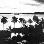
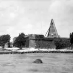
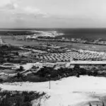
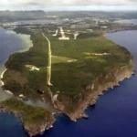
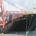
Table of Contents
Share This
Home to port and Naval station
Apra Harbor is a deep water port located on the west coast of Guam. It is home to both the commercial Port of Guam and Naval Station Guam.
Meaning of name
Apra is a corruption of the CHamoru/Chamorro word “apapa” which means “low.” Apapa is the original name for what is now known as Cabras Island. During Spanish times a saint’s name was added and the area became known as the port of San Luis de Apra.
Geography
Apra Harbor is framed by Orote Peninsula in the south and the Glass Breakwater and Cabras Island in the north. There are several streams that flow into the harbor from the hills of the villages of Piti and Sånta Rita-Sumai. The harbor is divided into several smaller bodies of water. The Commercial Port of Guam is located in the northeastern part of the harbor on Cabras Island and adjacent to the Piti Channel. South of the port is Sasa Bay, a recreational area and marine preserve. Naval Station Guam is located further south at the Inner Harbor. The larger body of water to the east is called Outer Apra Harbor.
History
Apra Harbor, with its rich fishing grounds, was home to many CHamoru/Chamorro villages in ancient times. However, during Guam’s early Spanish era (late 17th and early 18th centuries) the southern village of Humåtak and central village of Hagåtña were the preferred ports.
Apra Harbor was not used to its full potential because of its many reefs and coral heads. Apra Harbor did, however, become a preferred site for foreigners who wanted to avoid Spanish authorities. The British privateer John Eaton is reported to have anchored there in 1685 to barter with Chamorros. Others would follow in attempts to yield economic profit.
In response to pirates or privateers that threatened Spain’s profitable galleon-trade and missionary efforts, several fortifications were built not only to protect from enemy attack, but also as a harbor that provided protection from inclement weather. From 1737 to 1801, the Spanish government ordered the construction of three fortifications to defend the harbor.
In 1710, Fort Santiago was built atop Orote Peninsula, followed in 1734 with the opening of an anchorage near what would become Sumay village, and in 1737 Fort San Luis was built to protect this new anchorage. Around 1800, Fort Santa Cruz was built on a reef near the present day entrance of the Inner Harbor.
Development under the Americans
Apra Harbor became more important in the 19th century when the ports of the villages of Piti and Sumay came in to more frequent use. Piti was the primary port for the people of Hagåtña, while Sumay was a popular stopping place for whalers. At its height in the 1840s as many as 60 whaling ships stopped at Apra Harbor per year. In fact, while Hagåtña was the capitol of the island, Sumay developed into a commercial and financial hub during the 19th century.
During the whaling period, early in the century, Apra Harbor was considered to be among the few outstanding ports throughout the Pacific, a sentiment later shared by American sea captains during the Pacific war period. However, by the end of the century, the whaling era was coming to an end and the island’s economy was in decline. When US Naval Captain Henry Glass came into Apra Harbor on 20 June 1898 to claim the island for the United States he soon learned that forts Santiago and Santa Cruz had long been abandoned.
During the early 20th century, the US Navy began to develop the harbor, but even then, Apra Harbor was treacherous for large ships making it necessary to use launch boats to navigate the coral reefs to get to Piti and Sumay. With the coming of US Naval Government was an accompanying detachment of US Marines and the establishment of a marine barracks at Sumay. In 1903, Sumay became the site of a telegraph cable station which linked Guam with the rest of the world.
During the Naval administration Apra Harbor was used as a coaling station for ships coming from the US to Asia, and by the 1930s with the arrival of Pan American Clippers transformed the island’s communication and transportation patterns. In 1935, Sumay became the site of the Pan American Hotel and seaplane base which brought business and high profile visitors. Pan Am ran flights from San Francisco to Manila and included layovers in Honolulu, Midway, Wake, and Guam, and the airlines also operated a 20-room hotel in Sumay. These flight routes made Guam the “Hub of the Pacific,” so the routes also extended into Macao, Hong Kong and Shanghai. The flight routes also provided for increased mail delivery by 50 percent that were only interrupted by World War II.
In the 1930s Japanese crew and captains also docked at Apra Harbor. Leading up to World War II, Japan closed all of its mandates to outsiders and increased fortifications. Japan continued to trade in Guam, however, with the tactical advantage of obtaining useful geographical data about the island through trade. With a strategic eye, US Navy Rear Admiral Arthur J. Hepburn recommended that fortifications begin in Guam as an air and submarine base to the tune of $200 million with plans for improvements to Apra Harbor in 1938.
The US Naval General Board balked at the price tag, lowering it to $5 million, and designating recommendations primarily for Apra Habor infrastructure. The US Congress, not wanting to threaten Japan in the increasingly tense times, rejected all plans and instead rescinded docking rights to foreign boats. The decisions not to fortify the harbor would later have disastrous consequences for Guam as its ability to defend itself had been utterly compromised.
With the American recapture of Guam from the Japanese in July and August, 1944, all of the land abutting Apra Harbor was taken over by the US Navy as the island was transformed into a military fortress. The villagers of Sumay were relocated to a new village named Sånta Rita-Sumai and other parts of the island while the village of Piti was also relocated so that today it no longer fronts the Piti Channel. The Inner and Outer Harbor underwent extensive dredging and the Glass Breakwater was constructed on Luminao (earthquake) Reef and the Calalan Bank.
Apra Harbor today
Today, most of Apra Harbor remains under US Naval control. However, some areas such as Sasa Bay, the Piti Channel and parts of Glass Breakwater are accessible to the public. The land where the commercial port is located was transferred to the Government of Guam in 1969.
Apra Harbor today is not only an important port but also a popular recreation area for personal watercraft user, boaters, and surfers. Apra Harbor is also home to several shipwrecks that are popular with scuba divers. The two most well known wrecks are the World War I-era German merchant ship, SMS Cormoran, and the World War II-era Japanese freighter, Tokai Maru which lie side by side on the ocean floor.
For further reading
Farrell, Don A. The Pictorial History of Guam: The Americanization 1898-1918. 2nd ed. Tamuning: Micronesian Productions, 1986.
Pacific Wrecks. “Apra Harbor.” Last modified 31 August 2020.
Rogers, Robert. Destiny’s Landfall: A History of Guam. Honolulu: University of Hawai’i Press, 1995.
US Naval Research Laboratory. Typhoon Havens Handbook for the Western Pacific and Indian Oceans. Edited by Sam Brand. Report NRL/PU/7543-96-0025. Washington, DC: NRL, 2008.