
History of Guam's Parks and Public Spaces


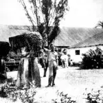
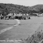
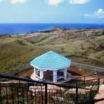
Table of Contents
Share This
Development of public lands as cultural and recreational spaces
Public beaches, parks and other open spaces are such a major part of people’s lives on Guåhan, it may feel as if access to them has always existed. On these community lands, people celebrate birthdays, weddings, baby showers, and family get-togethers; people walk their dogs; search for shells, fish, swim, and snorkel; we spend hours hanging out with friends or admiring seascapes.
However, public spaces for recreation, rejuvenation, education and exercise – open to all – is a relatively new concept. This is especially true in Pacific Islands, where land, offshore waters and the natural resources associated with them are finite; have lengthy histories of tenure and use rights; and serve as sources of individual, family, and clan identity. Along with the historic changes in Guåhan’s society and governing structures, the rules guiding control and development of the island’s land and sea have evolved over the centuries. Reflecting those changes, the community assumes a responsibility to protect those lands and waters, and to determine the future of Guåhan’s public spaces.
Indigenous CHamoru/Chamorro connections to the land
The CHamoru/Chamorro people have a special connection to the land and sea of Låguas and Gåni, the indigenous names for the southern and northern island groups respectively – what we now call the Mariana Islands. Arriving 3,500 to 4,000 years ago, the Austronesian-speaking ancestors became uniquely CHamoru in their island homeland over the millenia. They had a reciprocal relationship with the land and sea and everything that lives within them. While they shaped and transformed their environment, they were, in turn, shaped and transformed by the land and sea.
What was likely to have been more mobile lifeways in the early Pre-latte era, became more permanent settlements over time with a growing set of rules regarding rights to the land and sea and a community’s use of them. Whether living along the coast or inland, i manaotao mo’na likely had access to a variety of resources, either through direct access to rivers, seas, ponds, wetlands, coastal plains, ridges, and valleys; or through reciprocal exchange relationships with one another.
These patterns of access and use also included voyaging to other islands within Låguas and Gåni to connect with i manaotao mo’na (CHamoru ancestors) there; to fish, hunt, and gather resources available on those islands. For example, at certain times, i manaotao mo’na would travel to northern islands like Agrihan (Agrigan) to obtain wood for canoes and Ulåkas (Uracas) to hunt and harvest seabirds.
The principles, practices, and protocols that guided their right to access and use the land and sea were quite different from today’s modern concepts of individual land ownership and government-owned public spaces. Particular types of spaces existed for communal activities and rituals. Within a village and the various hamlets and areas associated with it, for example, from a ridge to a reef, access and use of resources would have required obtaining the right to do so from one’s matrilineal clan or village. This permission would embody a sense of obligation to others in one’s clan or village to sustain these resources so that the needs of all could be fulfilled. These norms also guided relations among Guåhan’s clans and villages as well as in other islands within the Låguas and Gåni archipelago. Ideally, they allowed community needs to be met while maintaining family, lineage, clan, and village relationships. While competition for resources was common (perhaps ending in interpersonal conflict or group warfare), social ties could be strengthened through systems of exchange, marriage, alliance, or by helping each other in times of need, feasting, and gift-giving.
Transformations of land: concepts, use, and maintenance
Communal systems of resource access and use rights have evolved over time, and in some ways continue to exist today. CHamoru responses to the socio-political forces of missionization, colonization, globalization and modernization have transformed indigenous practices and protocols regarding control of the land and sea. The introduction of the concepts of private land ownership and government-controlled public spaces accessible to the community-at-large (and visitors) has had a major impact on traditional views.
Spanish missionization and colonization (1668-1898) were the first of these forces to reshape CHamoru connections to the land and sea of their island homeland. What was once a matter of negotiation among CHamoru clans and villages became dictates of the church and colonial administrators. Through various means, including policies, decrees, penalties, and military force, the Spanish government enforced the introduced practice of formally delineating land ownership to individuals, institutions, and the government.
In many ways, these transformative forces disconnected CHamorus from their clan lands and their social and cultural practices and identities that had been tied to those lands. At the same time, much of the CHamoru reciprocal relationship with – and respect for – the land and sea remained, although these also continue to be challenged. The disconnections may be felt even more strongly for CHamorus born and raised away from their islands, especially those who have not been to Låguas and Gåni. Yet they too may be inspired to continue indigenous principles, practices, and protocols regarding the land and sea.
The concept of public land introduced by the Spanish colonial administration defined areas accessible to all regardless of the clan, village, or island. Over time, through various decrees, gifts, and warfare, the Jesuits acquired ‘’church’ lands, and the colonial government appropriated ‘Crown’ land, while a number of individuals (and families) gained private ownership of large tracts. The new types of public spaces included civic squares, manicured grounds surrounding government buildings, gardens, roads, roadside shrines and markers, beaches, and parks. Some of these spaces were used as promenades and for church processions, a custom that continues today. Several major public areas were established during the Spanish administration—Plaza de Magallanes (after Magellan, more recently referred to as the Plaza de España.), and Jardincitos de Villalobos. Towards the end of the Spanish administration, another public park was planned for Hagåtña.
Hagåtña, declared a city (ciudad) in 1686, and the seat of the colonial government, had many of these introduced public spaces. Some examples are parks in the San Ignacio and Santa Cruz barrios of Hagåtña, associated gardens situated across from the San Antonio bridge and the main walk from Hagåtña to Piti which served as a promenade of sorts, a place to be seen, where one could showcase oneself.
The Spanish also introduced the system of regulating and maintaining these spaces, including determining acceptable public behavior in them. For example, the colonial government, rather than the clan, developed rules about the use of shared spaces and resource areas, such as regulation of fishing in the ocean. CHamorus and other locals, as subjects of the Spanish Crown, now paid government taxes and were obligated to spend 40 days a year carrying out public work to sustain and maintain shared spaces. This labor included building, repairing, and maintaining public areas. For instance, people had the responsibility to maintain the section of road in front of their houses.
During these transformative centuries, CHamorus indigenized this new, imposed order. They spent time at their ranches, where they were able to behave in more traditional ways than they were in villages regulated by the government. Individuals and families continued to carry out various traditional roles on the land and in the sea to produce food or income for the family or lineage.
Following the Spanish-American war of 1898, the US colonial government established on Guåhan, continued to follow many of the Spanish-introduced ways of conceiving of land tenure and use, adding additional concepts and practices. Much of what exists today on Guåhan, in terms of the types of public lands and spaces and the way they are defined, managed, and regulated by the government, follows US models. At the same time, CHamorus have continued to indigenize and localize some of these introduced models as a means of continuing traditional concepts, practices, and protocols. Even today, many CHamorus continue to find ways of maintaining their privately-held land for the use and benefit of the family as a whole, following an ‘our land’ rather than ‘my land’ outlook and practice.
One of the largest challenges facing CHamorus, however, has been the colonial land appropriation policies of the Spanish and US governments, which directly affected traditional communal land practices and impacted indigenous control and use. .The most radical period of land seizures followed World War II, when the US military government controlled more than two-thirds of the land on Guåhan.
As of 2020, one-third of the island’s land is claimed by the federal government, which also claims or uses other large tracts of land in the neighboring Commonwealth of the Northern Mariana Islands. Land and sea resources that used to sustain families is now property that has been taken or leased to serve US military needs. Especially contentious for CHamorus on Guåhan are the tens of thousands of acres unjustly taken from families in the 1940s, during and after WWII. Much of this land was never used or was used for military-only recreation, not for direct defense purposes, drawing the most criticism and hard feelings.
In response to indigenous calls for returning the land as promised, portions of land seized by the federal government have been turned over to the Government of Guam, and some of these properties were returned to the families that had previously owned them for generations. With the establishment of a locally-elected government by the 1950 Organic Act, the US had transferred sizeable tracts of land to the Government of Guam, which has designated a significant portion of that land as publicly accessible beaches and parks, conservation areas, cemeteries, recreational areas, historic sites, and national landmarks. Some of these properties are held in trust as a means to restore access to land for families that had their land taken by the US between 1898 and 1968.
Current landscape of public spaces in Guåhan
Currently, Guåhan has more than 1,200 acres of parks, recreation areas, and other public lands that are owned and managed by the Government of Guam or the federal government. Additionally, private owners also manage properties for public use, including churches, civic organizations and commercial enterprises. While there has been significant growth in the number of beaches, parks, and sports/recreational facilities that serve the island community, visiting military, and tourists, the heavy use of these public areas also reflects major social changes in how, where, and with whom we spend our leisure time.
Parents, grandparents, and great-grandparents share stories of spending more time in their younger years by participating in family-oriented subsistence activities at the house or ranch to garden, raise livestock, gather foodstuffs, fish, and hunt. They also would process and cook food in these spaces, sharing it among family, friends, and neighbors.
Fewer of today’s younger generations spend time in these traditional ways; instead, spending more of their time participating in modern types of recreational activities, from flying kites, skateboarding, and paddling to making internet videos, and playing computer games.
Although Guåhan leaders drew up plans for parks and recreational areas during the early US administration, it was not until the first decades of locally-elected government and home rule (the 1950s through the 1970s) that the local government established most of the scenic sites, beaches, parks, and conservation areas used today. Several trends paved the way for development of these public spaces: the post-World War II shift to a fully cash-based economy; increasing urbanization; the ability for Guåhan’s community to access modern modes of transportation via new roads and bridges around the island; and an increasingly diverse population.
Another significant factor was the end of the long-drawn out security clearance requirements that had been in place from 1941 to 1962. The lifting of the restrictive security clearance for entry to the island offered the potential for establishing a tourism industry, capturing the imagination of many CHamorus eager to develop the island’s economy. Another impetus was the availability of sizable federal grants which were leveraged specifically for parks development.
Development of the Department of Parks and Recreation (DPR)
A Parks and Monument Committee, later named the Parks, Monuments, and Museum Committee, was developed by the Government of Guam. Over time several government agencies performed the work of developing and maintaining the island’s budding public spaces, including the Department of Commerce and the Department of Public Works, until the establishment of the Department of Parks and Recreation (DPR). To tap federal funding and ramp up the development of a viable tourism industry, studies were carried out, resulting in lengthy lists of public sites and activities that could be developed, generating a lot of community interest. However, all too often, the effort did not receive adequate sustained funding to support the planned development.
Over the decades, adequate funding has been the number one pressing issue in maintaining the island’s public spaces on behalf of the people of Guåhan. In fact, over the last three or four decades, the DPR’s personnel, purported to consist of a 200-member staff in the 1980s, has been shaved down to a mere 40 employees, while a once robust middle management group has become essentially non-existent.
Also lost over the years was the Marianas Recreation and Park Society, a civic organization that met regularly in the late 70s and early 80s. This key support group brought together professionals from both the local and federal governments to explore and tackle public lands for cultural and recreational use issues. Severe financial limitations, losses of personnel and expertise, as well as the impact of some political appointees viewed as lacking the interest or capability to direct the large and multi-tiered department, has crippled DPR’s ability to adequately serve the public’s evolving needs.
Other problems also challenge the success of Guåhan’s parks and public spaces, especially littering, defacing or destroying public facilities. While these might be viewed as new problems, they were foreseen as early as 1968, when Government of Guam laws were written to address these issues (e.g., PL09-125, 1968). Some speculate that these problems may be tied (to some degree) to the forced transition from traditional pre-colonial types of shared communal spaces that were guided by specific family and clan-based principles, practices, and protocols.
The Department of Parks and Recreation, as we know it today, was not officially established until 1975. Its predecessors included a Parks and Recreation division in the Department of Commerce as well as an earlier iteration as a Parks and Grounds Division. Robert Cruz, who had been a Deputy Director of the Parks and Recreation division at Commerce, served as the first Director of DPR. At that time, the department consisted of 57 public areas, including beach parks, parkways, scenic view sites, historical landmarks, and one public cemetery. This list has grown to include a Territorial Seashore Park, oversight of historical and cultural sites, and conservation areas, and numerous recreational facilities held in trust for the people of Guåhan.
Over time, responsibility for parks and recreational facilities have been informally and formally shared with village mayors. Additionally, the Guam Department of Education, US Department of Defense, charter and private schools also maintain playgrounds, athletic fields, and similar recreational facilities. Further, the Department of Agriculture along with locally-based federal agencies manage fisheries and other wildlife aspects of outdoor recreation.
Parks and other public spaces often retain traditional names or are named after local civic leaders, such as Padre Palomo, other prominent people associated with the island, or important indigenous groups. For example, a park developed in Humåtak pays tribute to the sons of Guåhan lost in the Vietnam War.
While most parks, once developed, have remained as such, some have come and gone or have been renamed over the years. There once was a Bradley Park in Anigua, and the Latte Stone Park in Hagåtña was renamed the Senator Angel Leon Guerrero Santos Latte Memorial Park in recognition of the late senator’s regular visits to the park to commune with ancestral spirits associated with the latte.
Federal parks and areas for recreation and conservation
Federal entities also have spaces established as parks as well as recreation and conservation areas on Guåhan. The National Park Service (NPS) developed a War in the Pacific National Historical Park in 1978. It consists of seven units in the central-southern part of the island. There also are federal conservation areas, such as the Ritidian National Wildlife Refuge and the Orote and Haputo Ecological Reserve Areas.
The US Department of Defense, occupying large swaths of what are often described as some of the ’best spots’ on the island, have developed numerous beaches, parks, and recreational facilities which have varying layers of restrictions. Most of these, if not all, are not available to the people of Guåhan. Over the years these spaces have had various levels of segregation based on military status, military rank, and skin color. The military issue their own fishing and hunting licenses, apart from the Government of Guam’s Department of Agriculture, and conduct hikes and tours inside and outside their bases and other federal properties.
Through a programmatic agreement, the Department of Defense is required to provide public access to about 66 cultural, historic, and other sites located on military bases; numerous other sites on the bases remain inaccessible. The processes for applying for this limited access are multi-layered and time consuming, which many in the community have noted as problematic and not meeting the spirit of the agreement. For yo’åmte (Indigenous CHamoru healers) in particular, time is of the essence in gathering åmot (traditional medicine) making it especially difficult – if not impossible – to conduct their practice. This is but one of several concerns CHamorus have regarding this limited access. The community has called for key indigenous cultural sites to be more readily accessible to the people of Guåhan and for the access process to be streamlined.
Additionally, more than 130 local historic sites and four natural landmarks on private, local government or federal land, are listed on federal registries—the National Register of Historic Places and the National Natural Landmarks (NNL). To continue to receive federal NPS grants which help support the island’s Historic Preservation Office, Guåhan is required to nominate at least one site to the national register each year. The local government also is exploring its participation in the NPS National Heritage Areas program. While this program does not require federal ownership of the land containing the qualifying heritage, these areas are designated as such by Congress.
Looking toward the future of public lands
In the Guam North and Central Land Use Plan, community members of Guåhan stated that they are interested in more public spaces, such as parks and recreational facilities, as a means to develop a better quality of life. At the same time, there is the potential to revise the mission of Guåhan’s parks and other public spaces according to indigenous, traditional, and new societal values, practices, and expectations. Public discussion of possible future developments have included incorporating community gardens, planting more fruit trees and native vegetation, recreating indigenous spaces, having a broader range of sports and community activities, and encouraging neighborhoods to use their parks more regularly as a means to reclaim them. DPR also explored new developments such as dog parks, the first of which exists in Dededo.
Public parks, cultural and historic sites, and recreational areas (in their modern sense) are relatively new concepts. At the same time, because societal views, values and practices evolve, it is important for the people of Guåhan to address the shape, use, and direction of public spaces on the island and for the community to meet the challenge of adequately maintaining and nurturing them.
For further reading
Beaty, Janice J. Discovering Guam: A Guide to its Towns, Trails and Tenants. Tokyo: Tokyo News Service, 1967.
Bevacqua, Michael Lujan. “History of Guam’s Parks and Public Spaces.” Zoom interview by Dr. Kelly Marsh-Taitano. Modern Guam Rises from Destruction of War: 1945-1970, Guampedia, 21 June 2021.
Camacho, Keith L. “‘Enframing I Taotao Tano’: Colonialism, Militarism, and Tourism in the Twentieth Century Guam.” MA thesis, University of Hawai’i, 1998.
Carano, Paul. Guam Scenic Route. MARC Working Papers #9. Mangilao: Micronesian Area Research Center, University of Guam, 1979.
Cruz, Mike. “History of Guam’s Parks and Public Spaces.” Zoom interview by Dr. Kelly Marsh-Taitano. Modern Guam Rises from Destruction of War: 1945-1970, Guampedia, 08 June 2021.
De Oro, Art. “Pattida: Dividing Family Land Among Children.” In Guampedia, last modified 19 May 2021.
Guam Bureau of Statistics and Plans. Draft North and Central Guam Land Use Plan. #00824.08. Seattle: ICF International, 2009.
Guam Department of Parks and Recreation Parks Division. Guam Comprehensive Outdoor Recreation Plan. By the Guam Department of Parks and Recreation. Hagåtña: DPR, 1977.
––– Guam Historic Preservation Plan. By the Department of Anthropology, Bernice P. Bishop Museum; Belt, Collins & Associates; and the Guam Department of Parks and Recreation Parks Division. Hagåtña: DPR, 1976.
Guampedia. “Seaton Schroeder General Order Nos. 22 – 32 and 35 – 48.” Last modified 12 March 2021.
Herman, R. Douglas K. “Inscribing Empire: Guam and the War in the Pacific National Historical Park.” Political Geography 27, no. 6 (2008): 630-651.
Hezel, Francis X., SJ. “It’s My Own Land, Isn’t It?” Micronesian Seminar Productions. Streamed live on 21 May 2016. YouTube video, 21:59.
Lotz, Dave. “History of Guam’s Parks and Public Spaces.” Zoom interview by Dr. Kelly Marsh-Taitano. Modern Guam Rises from Destruction of War: 1945-1970, Guampedia, 11 May 2021.
Madrid, Carlos. “History of Guam’s Parks and Public Spaces.” Zoom interview by Dr. Kelly Marsh-Taitano. Modern Guam Rises from Destruction of War: 1945-1970, Guampedia, 7 May 2021.
Marsh-Taitano, Kelly G. “An Exploration of Indigenous Values and Historic Preservation in Western Micronesia: A Study in Cultural Persistence.” PhD diss., Charles Sturt University, 2013.
––– “What it Means to Be One Archipelago.” The Guam Daily Post, 14 April 2019.
Marsh-Taitano, Kelly G., and Tiara R. Na’puti. “Pacific Islanders in the U.S. and Their Heritage: Making Visible the Visibly Absent.” In Finding a Path Forward: Asian American Pacific Islander National Historic Landmarks Theme Study. Edited by Franklin Odo. National Park Service: Washington, DC, 2017.
Micronesian Archaeological Research Services. “Resettlement Patterns Under American Rule.” In Guampedia, last modified 2 March 2022.
Na’puti, Tiara R. “Archipelagic Rhetoric: Remapping the Marianas and Challenging Militarization from ‘A Stirring Place’.” Communication and Critical/Cultural Studies 16, no. 1 (2019): 4-25.
Palomo, Tony. “Guam’s Scenic Areas Can Be Tourist Attractions.” The Territorial Sun, 15 October 1961.
Phillips, Michael. “Land Ownership on Guam.” In Guampedia, last modified 3 March 2022.
Quimby, Frank. “Security Clearance on Guam.” In Guampedia, last modified 23 March 2022.
Russell, Scott. “Gani Revisited: A Historical Overview of the Mariana Archipelago’s Northern Islands.” Pacific Studies 21, (1998): 83-105.
Sanchez, Pedro C. Guahan Guam: The History of Our Island. Hagåtña: Sanchez Publishing House, 1990.
Tolentino, Dominica. “Ancient CHamoru Kinship and Land Tenure.” In Guampedia, last modified 19 July 2021.
––– “Mannakhilo’ and Mannakpåpa’.” In Guampedia, last modified 17 May 2021.
US Department of the Interior National Park Service. Park and Recreation Areas, Territory of Guam. By Irving C. Root. Washington, DC: NPS, 1952.
US National Park Service. “Guam – List View.”