
Tamuning-Tumon-Harmon (Tamuneng-Tomhom)

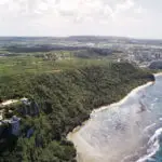

Table of Contents
Share This
Origin of village name in CHamoru
“Tamuning” is a Carolinian word which was given to the area where Carolinians settled beginning in 1849, after a typhoon devastated Lamotrek and Satawal. It may be that Tamuning is the name of the Carolinian chief’s clan. The American administration relocated the Carolinian population of Tamuning to Saipan in the early 20th century. Another name for Tamuning during the 19th century was Maria Christina. The ancient CHamoru/Chamorro name for the area was “Apurgan” or “Apotgan.”
Other major parts of modern-day Tamuning include Tumon (the island’s tourism district) and Harmon (the island’s industrial park). The original meaning of “Tumon,” known as “Tumhun” in the 17th century, has been lost. Harmon is named after Lieutenant General Millard F. Harmon, commanding General of the U.S. Army Air Forces/Pacific Ocean Areas (AAF/POA). Harmon, along with Brigadier General James R. Andersen, were lost at sea during a flight from Guam to Honolulu on 25 February 1945. Both men had Guam airfields named after them, but Harmon field was returned to the government of Guam and has since become an industrial park.
Population
As of the 2010 US Census, there were 19,685 residents living in the Tamuning, Tumon, Harmon village.
Village officials
Louise C. Rivera is the mayor and Albert M. Toves is the vice mayor.
Village description
The main geographic features of this region are the low plateau of Oka (Saupon) Point which divides Tumon and Hagåtña bays, and the Tumon Bay area which is enclosed by high cliffs leading to relatively flat Upper Tumon/ Harmon areas.
Tumon, with its beautiful white sand beaches and protected waters, has developed over the last four decades into Guam’s tourism center while Tamuning has become a major commercial and residential area. Harmon, the sight of the post-World War II airfield, is now an industrial park.
Village history
Tamuning and its surrounding areas have a rich history. The large number of latte stones and other archeological finds around Tumon Bay are evidence that Tumon Bay, with its freshwater springs and excellent inshore fishing, has long been a major population center of the island. During the Spanish conquest of Guam in the late 17th century, Tumon (Tumhun), Ipao, and Apotguan were all listed as major villages.
However, with the resettlement of CHamorus during the Spanish-CHamoru wars, the area was completely emptied of people. For the next two centuries, the area was primarily used for ranching, hunting, and fishing. The village of Tamuning was established in 1849 by Governor Pablo Perez, as a refuge for a group of Carolinians whose islands had been destroyed by a 1848 typhoon.
During the US Naval Era, several changes came to the area. Unhappy with the cultural practices of the Carolinians, Governor Seaton Schroeder transported them to the neighboring island of Saipan, north of Guam, in 1901, which was then under the administration of Germany. Schroeder also established a leper colony at Ypao in 1902 which lasted until 1912 when its inhabitants were exiled to the Philippines, most never to be heard from again. During Guam’s American naval era, people began to settle permanently in this part of Guam and established the village of Dededo which was centered at the current location of the San Miguel Brewery building in Harmon but included what is now considered Tamuning and Tumon. Tumon was a popular fishing and salt-making area during these years.
World War II brought many changes to the Tumon-Tamuning region. Life went on as usual for the Dededo villagers who did not have to leave their homes during the war, but Tumon Bay was fortified by the Japanese and ranchers were restricted from the area.
Before Guam was reoccupied by the US military in 1944, most residents in this area were forced into Japanese concentration camps. After the war, when CHamorus began to return to the area, they discovered that their former homes and ranch lands were to be used by the US military for the new Harmon Air Force Base, which stretched from Two Lovers Point and Ukudu (Okkodo) to what is now the intersection of Airport Road and Marine Corps Drive. Much of the land in Tumon Bay was also now off limits because it had been designated as an Army Air Corps recreation area.
As the war came to an end the Unpingco, Santos, Pangelinan, and Leon Guerrero families returned to ranching and fishing in Tumon at the same time that the military was still using the area as a recreation zone. A conflict arose in 1949 when the military threatened to condemn the entire area before the signing of the Organic Act in 1950. As the military bulldozers came through, Segundo Unpingco stood in front of them with his shotgun. In order to prevent public outcry, the condemnation was stopped. Areas such as Ipao, and the present-day sites of Matapang Beach Park and Guma’ Trankilidat (a housing division for elderly residents under the Guam Housing and Urban Renewal Authority) that had been used by the military as recreation sites were then turned over to the Government of Guam.
The result was that Tumon remained in local hands. By the 1950s, Tumon families were building permanent houses where their ranches had been. In 1952, St. Williams Catholic Church was built to accommodate this community. However, by the 1980s, rapid development was changing life in Tumon and many of these residents ended up moving to other parts of the island and the continental US.
Tamuning also changed radically after the war. Before the war, Tamuning was a ranching area owned by the Perez, Dungca, Sanchez, Rivera, San Nicolas, Sablan, Palting and Rojas families. However, in the late 1940s, the village transformed radically as these families as well as many other refugees from Hagåtña began to build permanent houses in the new municipality. By 1952 Tamuning had 2,364 residents and by 1960 there were 4,232.
In the 1960s, Tamuning became Guam’s most ethnically diverse community as CHamorus were joined by statesiders, Filipinos, Hawaiians, and Asians who came to Guam with the military, the Civil Service or tourism-related industries and settled in this new urban center.
There are three village fiestas for three patron saints. Tamuning celebrates the feast day of Saint Anthony in June, and Saint Victor in August. Tumon celebrates its fiesta for Blessed Diego de San Vitores in January.
Ancient CHamoru area names include Fafai, Gogna, Naton, Ypao, Mamajanao, Oca, Saucio, Dungca, Satpon, Lipog, and Alupat.
Points of interest
Village map
Institutions
Blessed Diego Luis de San Vitores Church
This church, located in the heart of Tumon was originally dedicated as St. William’s Church in 1952. It replaced the small chapel built in 1948 at the site of the San Vitores monument. The parish priest had the chapel removed because beachgoers were using the confession booths as changing areas. Following the beatification of Diego Luis de San Vitores by Pope John Paul II in 1985, the church was renamed in San Vitores’ honor. This church, like the San Vitores shrine, has long been a pilgrimage church attracting Catholics from all over the island. This is especially true now that most of the original residents of Tumon have moved out of the village since the building boom of the late 1980s.
St. Anthony Catholic Church
This church is located on Chalan San Antonio. It is the church of the Tamuning community that developed in the years following World War II. The first church built in Tamuning was St. Victor’s Chapel, which opened in 1946. The name has since been changed to St. Anthony, but St. Victor remains a patron saint of the village.
Schools
Chief Brodie Memorial School, Tamuning Elementary School, John F. Kennedy High School, Lyndon B. Johnson Elementary School, St. Anthony Catholic School, and St. John’s School (public and private schools) are all located in Tamuning.
Historical
San Vitores Monument
This monument marks the sight where Blessed Diego Luis de San Vitores was killed by Chief Matå’pang on 2 April 1672. San Vitores is credited with bringing Catholicism to Guam and his death sparked the Spanish-CHamoru Wars. CHamorus have been maintaining this site since the day he was murdered and it has long since been a pilgrimage site for Catholics from all over the island. In 1940 a concrete monument was placed here, but it was damaged during World War II. In June 1968, a new monument was dedicated.
Ypao Beach Park
Governor Joseph Flores Memorial Park, more commonly known as Ypao Beach Park, is Tumon’s largest and oldest beach park. It is on the site of an ancient CHamoru burial ground, which are known to exist throughout Tumon. It was also the location of a leper colony established by the US Naval government, from 1902 until 1912 when victims of leprosy were banished to the Philippines. Today, Ypao Beach accommodates residents and tourists. The park is a popular weekend location for local festivals, barbecues, and parties.
The waters off the park are part of the Tumon Bay Marine Preserves, where fishing is limited and the taking of marine life is prohibited. This is an effort of the local government to preserve the island’s marine resources.
Recreational
Cushing Zoo
The zoo is located next to Matapang Beach Park and is Guam’s only zoo. It was founded by Frank and Margie Cushing who came to Guam as a circus act to entertain the troops in the 1950s. Their children continue to run the family business.
Guam Premier Outlets
This outlet mall sits along Chalan San Antonio. There are many shops and vendors for customers to peruse, a food court, and movie theaters. Many restaurants and grocery stores surround the area.
Matapang Beach Park
This park is dedicated to the CHamoru Chief Matå’pang. Today, numerous outrigger canoes are based here, used by local canoe clubs.
Tumon- Tourist District
Tumon is the island’s tourist district. The white-sand beach front properties are lined with luxury hotels. In an area known as Pleasure Island, high-end shops, restaurants, bars, dance clubs, and various other establishments share the space with hotels.
Two Lovers Point
This imposing cliff marks the northern border of Tumon Bay and is a popular tourist attraction offering dramatic views. Two Lovers Point, or Puntan Dos Amantes, is said to be where two lovers jumped to their deaths during the early Spanish period, with their hair tied together.
Village mayors/commissioners
- Louise C. Rivera, Mayor, 2013- Present
- Francisco C. Blas, Mayor, 2005-2012
- Concepcion B. Duenas, Mayor, 2001-2005
- Luis SN Herrero, Mayor, 1997-2001
- Alfredo C. Dungca, Commissioner/Mayor, 1985-1997
- Gregorio A. Calvo, Commissioner, 1965-1985
- Eugenio I. San Nicolas, Commissioner, 1957-1965
- Jose P. Castro, Commissioner, 1948-1957
- Simon A. Sanchez, Commissioner, 1946-1948
Vice mayors/assistant commissioners
- Albert M. Toves, Vice Mayor, 2021-Present
- Kenneth C. Santos, Vice Mayor, 2013-2020
- Louise C. Rivera, Vice Mayor, 2005-2012
- Nancy T. Leon Guerrero, Vice Mayor, 2001-2005
- Concepcion B. Duenas, Vice Mayor, 1997-2001
- Teresita C. Borja, Assistant Commissioner/Vice Mayor, 1989-1997
- Peter S. Calvo, Assistant Commissioner, 1985-1989
- Alfredo C. Dungca, Assistant Commissioner, 1977-1985
- Maria SN Leon Guerrero, Assistant Commissioner, 1969-1977
- William B. James, Assistant Commissioner, 1965-1968
- Gregorio A. Calvo, Assistant Commissioner, 1961-1965
- Manuel C. Perez, Assistant Commissioner, 1956-1961
Editor’s note: The preceding list was provided by Konsehelon Mahot Guåhan/the Mayor’s Council of Guam.
For further reading
Beaty, Janice J. Discovering Guam: A Guide to its Towns, Trails and Tenants. Tokyo: Tokyo News Service, 1967.
GlobalSecurity.org. “Andersen AFB.” Last modified 5 July 2011.
Lévesque, Rodrigue. History of Micronesia: A Collection of Source Documents. Vol. 5, Focus on the Mariana Mission. Québec: Lévesque Publications, 1995.
Mayors Council of Guam. “MCOG – Mayors Council of Guam.”
Onedera, Peter R., ed. Nå’an Lugåt Siha gi ya Guåhan (Guam Place Names). Hagåtña: Chamorro Language Commission, 1988.
Rogers, Robert. Destiny’s Landfall: A History of Guam. Honolulu: University of Hawai’i Press, 1995.