
Humåtak/Umatac
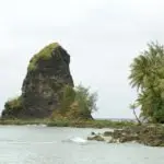
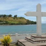
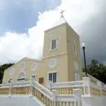
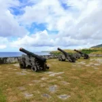
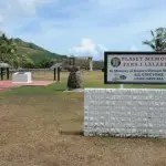
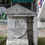
Table of Contents
Share This
Origin of village name in CHamoru
The village derives its name from the word uma, which means to carry something on the back or a heavy load on the shoulders.
Population
As of the 2010 Census, the population was 782, which is 105 fewer residents than in the 2000 Census.
Village officials
The current mayor of Humåtak/Umatac is Johnny A. Quinata.
Village description
The small village of Humåtak is located in southern Guam along Humåtak Bay. The community of Humåtak is relatively smaller than others on Guam and made up of a handful of residents, many of whom are related to each other.
Interspersed between old houses that sit along the bay’s shoreline are ruins that have become prominent reminders of the Spanish colonial era in the village. Plaque placed throughout the village describe the Spanish era to visitors. Remains of this era include the former Spanish governor’s residence, the site of the old San Dionisio church, Fort Santo Angel, and Fort Nuestra Senora de la Soledad.
A bumpy two-lane road runs through the center of the village, and visitors coming down into Humåtak from the steep hills in the north will first notice stones placed into a hillside in the shape of the island of Guam, welcoming them to the village. A couple of small stores and the San Dionisio Church, built at its current location in 1939, sit along the road.
The road, with houses built in the first half of the last century, then opens up into a spectacular view of the bay before coming to a small park with a children’s playground built by IT&E in the 1990s. Adjacent to the park is the mayor’s office, right on the beach, with perhaps the best view of any mayor’s office on Guam.
At the center of the bay is an obelisk monument to Ferdinand Magellan’s landing in 1521, bearing the inscription, “Magellan landed here.” The bay is also home to some of the island’s best surfing.
The road then crosses the Humåtak Bridge, constructed with towers reminiscent of London Bridge. The bridge dates not back to the Spanish times, as visitors often assume, but to the 1980s under the helm of Governor Ricardo J. Bordallo.
After the bridge, the road runs uphill, where visitors can turn off into a small park to see the ruins of Fort Nuestra Senora de la Soledad (commonly referred to as Fort Soledad), constructed to protect the bay from pirates and other European explorers. South of Humåtak is the village of Malesso’.
North of the main village and within Humåtak’s boundaries is an overlook to Cetti Bay, a beautiful secluded beach that can only be reached by hiking or sailing.
Village history
The history of Humåtak is among the most rich of all the villages of Guam, especially during the Spanish era. Among other distinctions, Humåtak is the home to Fouha Bay in which a rock called “Fouha” Rock sits. The ancient CHamorus believed this rock to be the resting place of a goddess called Fu’una who, with her brother Puntan, is credited with creating the world and people. The rock is also called Creation Point.
The pre-contact CHamorus made a pilgrimage to the rock every year to pay homage to Fu’una and to have their rice blessed to be used to cure people, according to Spanish accounts. Humåtak is perhaps most famous for being the site, by long oral tradition among the CHamorus/Chamorros, Ferdinand Magellan first landed on Guam. Humåtak residents still celebrate every March with a re-enactment of the 1521 landing on Guam History and CHamoru Heritage Day. The celebration was previously held every March 21, known formerly on Guam as Discovery Day.
The next landing by Europeans on Guam, that of Miguel Lopez de Legazpi, 44 years later in 1565, was indisputably at Humåtak. Legazpi anchored at Humåtak Bay for 13 days and formally claimed Guam for Spain. During his stay, a Catholic mass was celebrated in a large cruciform canoe house by the bay.
By the time of Legazpi’s visit, Humåtak was already a CHamoru coastal settlement that included a large communal house raised on latte stones, so spacious it could accommodate 200 people along with large canoes, as described by the Europeans. There were also other low houses in which the CHamorus cooked and roasted food.
Humåtak was the chief port for the Spanish during the early galleon days, when it was visited annually by a galleon from Aculpulco, usually in May or June. In late 1680, a Spanish settlement was established at Humåtak for the first time to serve the galleons, along with a supply ship that stopped on Guam from Cavite in the Philippines, usually in August or September. The supply ship brought necessities such as soap, flour, tools, metal, animals, and seeds. The galleon also brought supplies, but mainly Spanish money of Mexican silver to pay soldiers and mission personnel.
These visits were so important that the Spanish governor transferred his residence from Hagåtña to Humåtak when the ships were expected. Governor Damian de Esplana built the governor’s palacio, or palace, surrounded by a presidio compound inHumåtak in 1690. After the supplies were unloaded from the ships, they were transported by boat from Humåtak around Orote Point to Hagåtña since no road existed between the two towns.
Between 1680 and 1810, the first fortification built in the presidio was the Bateria de Nuestra Senora Del Carmen located in the bay. In 1756, Fort Santo Angel was built at the entrance of the bay on top of a large rock. The third structure, Fort San Jose, was built around 1805 on a hill located north of the village. Lastly, one of the most popular tourists sites on island, is Fort Nuestra Senora de la Soledad or Fort Soledad. It was built around 1810 above the southern part of the bay.
The Spanish attempted to link Humåtak and Hagåtña with a monumental road project with the help of Filipino workers, but the road was never completed. Remnants of the project are historical sites today, including stone bridges in Humåtak, Sella Bay, and Hågat.
Points of interest
Village map
Historical
Fouha Bay/Creation Point
Humåtak is the home to Fouha Bay in which “Fouha Rock” sits. The ancient CHamorus believed this rock to be the resting place of a goddess called Fu’uña who, with her brother Puntan, created the world and people.
FQ Sanchez Elementary School
Francisco Quinata Sanchez Elementary School, more commonly referred to as FQ Sanchez Elementary, is one of 25 public elementary schools on Guam. It was named in honor of Sanchez who was an 20th century pioneering educator and politician of Guam.
Because of its small student population, lawmakers proposed closing the school and sending its students to Merizo Martyrs Elementary School in the neighboring southern village. Humåtak residents, however, strongly opposed this move.
In 1998, the school was listed in both the Guam and the National registers of historic places. It was constructed in 1953 by world-renowned architect Richard Nuetra who also designed the Guam Government House.
Guam Veteran’s Memorial
The park overlooks the hillsides of Humåtak and is dedicated to the 74 CHamoru men listed on a plaque at the site who died in the Vietnam War. The park was developed by the Guam Women’s Club in 1971 and is a popular stop for tourists. A special Mass is held at the site each Memorial Day. Listen to CHamoru veterans of the Vietnam War from Guam here.
San Dionisio Church
The church of San Dionisio was constructed of wood with a palm thatched roof and dedicated in 1681. It was later burned in 1684 by those CHamorus who opposed the Spanish, rebuilt again of wood, and destroyed again by a typhoon in 1693. It was rebuilt in 1694 of coral masonry.
By 1690, after two European disease epidemics killed a large number of CHamorus, Humåtak was the largest of five parishes on Guam, with 700 people. In the early 1700s, Rota, Guam’s neighbor island to the north, was at times administered together with Humåtak by the church, resulting in close ties between the two parishes.
In 1849, a massive earthquake on Guam demolished many buildings including the governor’s palacio, the San Dionisio Church, and the convento (the priests’ residence). Only the church was rebuilt, of wood, and that structure was destroyed in the severe earthquake of 1902 that also crumbled part of the Dulce Nombre de Maria church in Hagåtña. The San Dionisio church was not completely rebuilt until 1939 at a new location, where it still stands.
The Spanish masonry ruins of the old San Dionisio Church, which are located within 50 yards of the current church, are marked by a plaque, and are on the National Register of Historic Places.
Spanish Forts
From 1680 until 1810, four Spanish fortifications were built around Humåtak Bay to protect the important harbor from pirates and privateers: Bateria de Nuestra Senora Del Carmen, Fort Santo Angel, Fort San Jose, and Fort Nuestra Senora de la Soledad.
The Bateria de Nuestra Senora Del Carmen was the first Spanish military fortification built around 1680 in Humåtak Bay. It was built to protect the Bay and the mouth of the Salupat River, a source of fresh water for the galleons and visiting ships.
Fort Santo Angel was the second military installation in the village of Humåtak during the Spanish Era. It is located on top of a large rock structure at the entrance of Humåtak Bay. The Fort Santo Angel structure is still visible today. To read more about Fort Santo Angel visit the entry here.
Fort San Jose was built in 1805 and was the third of the fortifications built in the village. The Fort was located on the hill before entering Humåtak Bay from the north. Today, little remains of the structure. To read more about Fort San Jose visit the entry here.
Fort Soledad is perhaps the most famous and is now a park site often visited by tourists. It is of the most recent construction, and while it has crumbled from weather, treasure hunters and World War II over the years, much of the fort remains intact. Click here to read the entry.
Humåtak Pride Outdoor Library
This library is not a building where you may expect to enter through a door, see windows, nor be covered by roof. This library is best described as a large, highly decorative, cement bookshelf.
This small monument-like structure, built in October 1933, served as a place where villagers could exchange books. It was built under the direction of early 20th century education pioneer and politician Francisco Quinta Sanchez, a resident of the southern village.
Located near the modern-day San Dionisio Catholic Church, the structure sits right next to the village’s main road, where visitors can see it as they drive through slowly. With its walls partially crumbled, it now serves as another reminder of Humåtak’s historic past.
Village mayors/commissioners
- Johnny A. Quinata, Mayor, 2013-Present
- Dean D. Sanchez, Mayor 2009-2013
- Daniel Q. Sanchez, Mayor, 2005-2009
- Tony A. Quinata, Mayor, 2001-2005
- Jesus A. Aquiningoc, Mayor, 1997-2001
- Jose T. Quinata, Mayor, 1992-1997
- Dean Q. Sanchez, Acting Mayor, 1991-1992
- Albert T. Topasna, Commissioner/Mayor, 1989-1991
- Cecilia Q. Morrison, Commissioner, 1985-1989
- Albert T. Topasna, Commissioner, 1969-1985
- Jesus T. Quinata, Commissioner, 1961-1969
- Jesus S. Quinata, Commissioner, 1952-1961
- Gregorio M. Camacho, (no title or dates provided))
- Helarion Quinata, Commissioner, (no dates provided)
- Agustin Quinata, Commissioner, (no dates provided)
- Jose Gofigan, Commissioner, (no dates provided)
Editor’s note: The preceding list was provided by Konsehelon Mahot Guåhan/the Mayor’s Council of Guam.
For further reading
Driver, Marjorie G., and Francis X. Hezel, SJ. El Palacio: The Spanish Palace in Agana, 1668-1898. MARC Education Series no. 26. Mangilao: Richard F. Taitano Micronesian Area Research Center, University of Guam, 2004.
Guam Department of Parks and Recreation. “Guam State Historic Preservation Office.”
Mayors Council of Guam. “MCOG – Mayors Council of Guam.”
Onedera, Peter R., ed. Nå’an Lugåt Siha gi ya Guåhan (Guam Place Names). Hagåtña: Chamorro Language Commission, 1988.
Rogers, Robert. Destiny’s Landfall: A History of Guam. Honolulu: University of Hawai’i Press, 1995.
Stephenson, Rebecca, and Hiro Kuroshina, eds. Umatac by the Sea: A Village in Transition. MARC Educational Series no. 3. Mangilao: Richard F. Taitano Micronesian Area Research Center, University of Guam, 1989.