
Islan Dåno’: Cocos Island
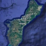
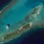
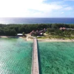
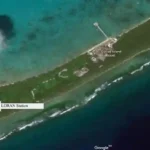
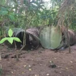
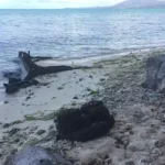
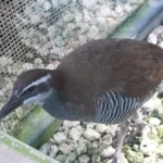
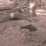
Table of Contents
Share This
Barrier reef off Malesso'
Located approximately 1.6 km southwest of Guam lies an uninhabited barrier island called Cocos Island, or Islan Dåno’ in CHamoru/Chamorro. Cocos Island is a 33.6-hectare atoll-like narrow island that spans a length of 1.93 km and a width of 0.15 km. The Island is situated within the barrier reef of Guam’s southwestern village of Malesso’/Merizo, making it part of the village’s municipality. Additionally, Cocos Island separates the coral atoll of Cocos Lagoon from the open ocean in the south (Figure 1 and 2).
There are three different types of natural habitat on the Island: beach strand, strand forest, and shoreline, and all have been colonized by different communities of plants and animals. Small beach strands are found along the shorelines of the Island, with larger beach patches found at the northern tip facing the lagoon. The soil of the Island is called Shioya loamy sand, which is a deep and very dry soil. Strand forest stretches across the entirety of the island, with vegetation mainly comprised of Casuarina forest, Pemphis and Scaevola scrub, and mixed strand forest (Figure 3). The island is home to various breeding populations of native wildlife species that include the endangered Såli (Micronesian starling), native lizards, and seabirds.
One of Cocos Island’s main uses includes the operation of a privately-owned resort, Cocos Island Resort, which is located on the northeastern side of the island. The Resort, along with roughly 24.8 ha (two-thirds) of the island, are privately owned. The Resort primarily caters to tourists who board a ferry off a private pier in Malesso’, for day visits to Cocos Island (Figure 4). The Resort offers an array of activities ranging from aquatic recreation, such as scuba diving and parasailing, to terrestrial activities, such as dune buggy rides and native bird watching.
The remaining area of the Island, approximately 8.8 ha, is a park controlled by Guam Department of Parks and Recreation (DPR), who are responsible for managing a different use of Cocos Island. Together with DPR, Guam Department of Agriculture’s Division of Aquatic and Wildlife Resources (DAWR) and Forestry Division, US Fish and Wildlife Service (USFWS), and Cocos Island Resort (CIR), Cocos Island has been designated as a wildlife conservation area managed by these agencies. Collectively, these agencies seek to re-establish some of Guam’s native flora and fauna that are at risk for extinction due to predation by invasive species. Due to Cocos Island’s lack of invasive predators, such as the brown tree snake that is present on Guam, the Island presents a rare opportunity for conservation efforts.
Paving the way for conservation
In order for Cocos Island to be used as a conservation area, the Island first had to be cleaned up. From 1944 to 1963, the United States Coast Guard (USCG) used the southern part of Island as a LOng-RAnge Navigation station, or LORAN (Figure 5). That land was eventually returned to the Government of Guam and is now known as Dano Park. However, the USCG did not take everything with them. Some physical remains of the station can still be seen on the Island and chemicals have been found in the soil and water. To this day, traces of these chemicals can still be found in the lagoon.
In 1965, shortly after the official closure of the LORAN station, high levels of polychlorinated biphenyls (PCBs) were found in the water of the lagoon and in the soil of the Island. PCBs were originally used in electrical equipment. They were eventually determined to be toxic and were banned by the US in 1979 due to reports of negative health impacts on humans and the environment. It is suspected that PCBs contaminated the soil and water through discarded equipment that was both buried on the Island and tossed into the lagoon (Figure 6). PCBs could have also entered into the water through runoff from the Island.
An investigation into the presence of contaminants on Cocos Island was conducted in 2005 and 2006 by the USCG. During the investigation, high levels of PCBs, lead, and cadmium were found. The USCG then contracted a local company to remove some remaining debris (Figure 7) as well as PCB contaminated soil for treatment. They also conducted regular tests of the soil and water. Soil removal was completed in 2008 but monitoring for the presence of chemicals continue.
With the completion of the soil removal, the Island was ready to be used as a conservation area. Guam Department of Agriculture’s Division of Aquatic and Wildlife Resources (DAWR) worked with Cocos Island Resort (CIR) to begin preparing the Island for use as a conservation area. Preparation included island-wide control of vertebrate threats and habitat maintenance. The complete eradication of rats on the Island was accomplished in 2009. The hilitai, or monitor lizard, population continues to be controlled by DAWR staff.
The Island’s habitat is currently being maintained by the Forestry Division of Guam’s Department of Agriculture, who are tasked with not only planting native flora species, but also removing and maintaining invasive plant species. These efforts enhance the Island’s habitat and contributes to the success of the ko’ko’, or Guam Rail, an endangered species (Figure 8).
Although the soil on the Island is no longer contaminated, the lagoon continues to hold high levels of the chemical contamination. In May 2015, the National Oceanic and Atmospheric Administration (NOAA) conducted an assessment to determine if any contaminants could still be found in Cocos Lagoon. They took samples of both fish and sediment from the lagoon, and confirmed that PCBs are still present, along with dichlorodiphenyltrichloroethane (DDT), which had not been previously detected on Cocos Island or in the Lagoon. DDT is a pesticide that was used to manage insect populations.
This chemical was banned in the US in 1972 because of the harmful effects it had on wildlife. The DDT found in the lagoon could have come from usage, or storage and disposal on the Island during the LORAN era. The official results of the NOAA assessment were presented to the public in 2016.
In 2006, Guam’s Environmental Protection Agency (EPA) and the Department of Health and Social Services placed a fish consumption advisory on fish caught in Cocos Lagoon. PCBs remain in the environment for a long time and can easily be ingested by fish. The more PCBs fish ingest, the more harmful consuming fish can be to humans. NOAA’s 2016 assessment confirmed that this advisory should remain in place. This advisory only warns against eating fish from the lagoon; it does not affect any recreational activities such as swimming or snorkeling. Despite the advisory, whether or not they are aware of it, fishermen still fish in the lagoon.
Cocos for Ko’ko’
The ko’ko’ is a ground–nesting flightless bird endemic to the island of Guam. Guam Rails are territorial, monogamous birds that can nest year-round, with an average of two to four eggs per clutch and an average of six clutches per year. The newly hatched Guam Rails can reach sexual maturity as early as six months and can then be paired with a mate in captivity or left on its own in the wild. The population of the rails was at an estimated 80,000 in the 1960s but had almost completely disappeared from Guam by 1983 due to an introduced predator, the brown treesnake.
Twenty-one wild birds, caught between 1984 and 1986, were considered to be the last of the remaining wild population and were brought into captivity in 1987. They are considered the founders of the Guam Department of Agriculture’s Division of Aquatic and Wildlife Resources (DAWR) captive breeding population (Haig et. al. 1990).
In September 2008, the Guam Department of Agriculture DAWR signed a Safe Harbor Agreement (SHA) with the Guam Department of Parks and Recreation (DPR), US Fish and Wildlife Services (USFWS), and Cocos Island Resort (CIR), to enhance the habitat of Cocos Island in order to introduce and establish a breeding population of ko’ko’. The SHA allows CIR to maintain and improve Cocos Island in order to create a stable habitat for the endangered bird, and releases liability of incidental take on their property. The SHA allows for the release of the Guam Rails on the Government of Guam (GovGuam) DPR south side of the Island known as Dano Park, with CIR acknowledging the conservation efforts for the Guam Rail on the island.
The first introduction of the Guam Rails occurred on 16 November 2010, with 16 captive-bred individuals released into Dano Park, on Cocos Island. Prior to release, each bird was banded and fitted with a radio transmitter in order to monitor the survival success of the release. Each ko’ko’ was monitored daily for six weeks, then for five days a week until the radio transmitters failed (at approximately six months). After that, Dano Park continued to be monitored for incidental sightings of Guam Rails and their nests.
In August 2013, another release of 10 birds occurred on the government side of the Island. The birds were again banded and fitted with radio transmitters and monitored for survival. Once the transmitter failed, live traps were set to attempt to capture Cocos Island-born rails to band, tag, and release back into the wild for monitoring (Figure 9).
The number of birds sighted, the number of nests, eggs, and chicks, and nest failures were recorded and documented. Information from the transmitted birds helped to determine established territories of released birds, allowed for incidental sightings of birds and nests. Both releases have contributed to a wild Cocos Island-born population to develop. Initially, the Cocos Island-born rails established territories in Dano Park but due to the increase of population and the decrease of vacant territories, they have started nesting within CIR property limits.
Since 2013, nesting and banded-bird success have been monitored and recorded. From August 2013 through March 2017, 35 Cocos Island born rails have been captured, banded, and monitored for survival success rate and territory size.
Cocos Island currently has an estimated population of approximately 35 wild Guam Rails, and DAWR hopes they breed more and spread throughout the Island. Annual census reports are conducted by DAWR and annual estimations are included in their Annual Performance Reports. The control of the hilitai population, along with the maintenance of invasive and native plant species throughout the Island, have all contributed to the success of the current population of the endangered Guam Rail on Cocos Island.
About the authors

Dareon Rios was a biology graduate student at the University of Guam Marine Lab, and a graduate research assistant for Guam’s Established Program to Stimulate Competitive Research (EPSCoR). She graduated in 2020. Her thesis was “The Population Genetic Structure of Acropora pulchra in Guam. “
Cristian “CJ” Cayanan was a part-time graduate student at the University of Guam Marine Lab. She was also a full-time Biologist for Guam Department of Agriculture’s Division of Aquatic and Wildlife Resources (DAWR).


Raina Taitingfong was a part-time graduate student at the University of Guam. She was also a full-time Biologist for Guam Department of Agriculture’s Division of Aquatic and Wildlife Resources (DAWR).
Editor’s note: These authors were beginning graduate students in 2018 taking a course in scientific writing at the University of Guam. This article was assigned to provide the student with practice in communicating science to non-scientists. The student chose the topic which is related either to their thesis project or work experience. The instructor in the course is Dr. Laurie Raymundo, a UOG Marine Laboratory faculty member.
For further reading
Haig, Susan M., Jonathan D. Ballou, and Scott R. Derrickson. “Management Options for Preserving Genetic Diversity: Reintroduction of Guam Rails to the Wild.” Conservation Biology 4, no. 3 (1990): 290-300.
US Department of Commerce National Oceanic and Atmospheric Administration National Centers for Coastal Ocean Science. An Analysis of Chemical Contaminants in Sediments and Fish from Cocos Lagoon, Guam. By S. Ian Hartwell, Dennis A. Apeti, Anthony S. Pait, Andrew L. Mason, and Char’mane Robinson. NOAA Technical Memorandum NOS NCCOS 235. Silver Spring: NCCOS, 2017.