
Fort San Luis

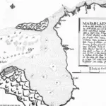

Table of Contents
Share This
Built to protect harbors
Fort San Luis was the first of three Spanish fortifications constructed to protect the anchorage at Apra Harbor. The fort was constructed on the northern shoreline of Orote Peninsula near present day Gab Gab Beach. This strategic location allowed the Spanish to defend ships that were anchored in both the harbor’s large outer section as well as its more shallow inner section.
The development of the new harbor was spurred by the increasing number of non-Spanish ships sailing through the Pacific in the early 18th century. Spain, wanting to deny the possibility of rival powers interfering with its Pacific trade route and missionary objectives, issued orders to strengthen Guam’s defenses. Apra Harbor was tested for depth and mapped during the administration of Governor Francisco de Cardenas Pacheco (1734-1740). In 1734, the new anchorage was opened and by 1740 most ships anchored in the harbor, as it offered ships better protection from enemy vessels and poor weather conditions than did the southern anchorages at Humåtak and Malesso‘.
In 1737, Fort San Luis was constructed to protect the new harbor. The fort was built close to the water’s edge and protected both the inner and outer harbors. Its walls were constructed of stone and mortar with dimensions measuring 40 feet long by 24 feet wide, with a height of 13 feet from its base to the top of its embrasures. The cemented stone structure was built atop a bare rock foundation. In a letter addressed to the King of Spain in 1738, Pacheco reported that the fort housed six cannons: two 10-caliber (500-yard range), one eight-caliber (475-yard range), one six-caliber (350-yard range), and two four-caliber (250-yard range).
Weaknesses
Although the fort’s location was strategic in the sense that it could protect the inner and outer harbors, it did have its flaws. First, it was not sheltered from behind except for a small hill, which enemy forces could overtake by landing at alternate sites. Second, the fort had no protection on either side of it, also making it prone to ground attack from troops landing at other sites. Finally, enemy fire could cause small land slides at the rear of the fort, impeding its efficiency in returning fire.
Like other Spanish fortifications on the island, Fort San Luis changed over the decades. In 1742, British Commodore George Anson received reports that San Luis had five eight-caliber cannons. In 1772, Lieutenant Julien Crozet, commander of a French expedition that anchored at Apra, described the fort as having eight 12-caliber cannons and, by 1817, Russian commander Otto von Kotzebue reported that the condition of the fort had declined and it was no longer in use.
Today, there are no visible remains of Fort San Luis.
For further reading
Degadillo, Yolanda, Thomas B. McGrath, SJ, and Felicia Plaza, MMB. Spanish Forts of Guam. MARC Publications Series 7. Mangilao: Richard F. Taitano Micronesian Area Research Center, University of Guam, 1979.
Driver, Marjorie G., and Omaira Brunal-Perry. Architectural Sketches of the Spanish Era Forts of Guam: From the Holdings of the Servicio Historico Militar, Madrid. MARC Educational Series no. 17. Mangilao: Richard F. Taitano Micronesian Area Research Center, University of Guam, 1994.
Guam Department of Parks and Recreation. “Guam State Historic Preservation Office.”
Lévesque, Rodrigue. History of Micronesia: A Collection of Source Documents. Vol. 13, Failure at Ulithi Atoll, 1727-1746. Québec: Lévesque Publications, 1998.
Rogers, Robert. Destiny’s Landfall: A History of Guam. Honolulu: University of Hawaiʻi Press, 1995.