
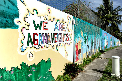

View more images for the Agana Heights (Tutuhan) entry here.
Origin of village name in CHamoru
Agana Heights sits just above the capital city of Hagåtña and was a resettlement community for many residents of old Hagåtña after World War II ended in 1944.
Before it was a village, many say the area was called Tutujan. Some village elders say that the place name Tutujan is derived from the CHamoru word tutuhon which means “to begin, start, or set out.” However, other elders say the tutuhan name is derived from the name of a trail along the cliffline between Fort Santa Agueda (also known as Fort Apugan) and Government House.
Population
The US Census in 2010 listed Agana Heights population at 3,808.
Village officials
The current mayor is Richard B. Arroyo.
Village description
The villages of Asan/Maina, Hagåtña, Ordot/Chalan Pago and Sinajana border Agana Heights.
The sections of the village are As Apugan, Tipugan, Fonte, Hilaan, Taigigao, and Charito. Fonte River divides Agana Heights from Maina village and Taigigao Street is the boundary separating Agana Heights from Ordot/Chalan Pago. Sinajana village and Agana Heights village are also separated by a shared roadway.
Before World War II, Agana Heights was a farming community for residents who lived in Hagåtña. Today, sprinkled throughout the village are some beautiful homes with gated and manicured lawns, quaint residential homes, apartment complexes, and a row of buildings that serve as homes to different religious denominations and organizations. Agana Heights has been transformed into a thriving community.
Agana Heights is home to historic Fort Apugan, also known as Fort Santa Agueda, located next to Government House. The village of Agana Heights also features Tutujan Park, completed in 2002, also known as “Triangle Park” for the triangular shape it takes as it located at the fork – in the middle of the road – that separates San Ramon Hill from Pale’ Kiernan Drive.
Village history
Before World War II, Agana Heights was primarily farm land for the residents of Hagåtña. It was also the site for the Spanish militia’s “lookout” for incoming ships and possible danger. That site today is Fort Santa Agueda, also known as Fort Apugan, which is a popular tour site because of its panoramic view of the island’s capital city, bay of Hagåtña, the Philippine Sea, and the sheer northern clifflines of Oka Point and Urunao Point.
The US military also used the area before World War II where the US Naval Hospital Marianas now stands, for officer’s quarters and a sick bay. During the war, the Japanese military used the facilities for training carrier pigeons as a means of communication. After the recapture of the island by US forces, the facilities were utilized as an internment camp for prisoners of war.
The village grew substantially after World War II, as people who owned land in Agana Heights moved there since the bombed capital of Hagåtña was off limits.
Today, Agana Heights is home of two of the island’s oldest organizations: the Elks Club and the Shriners Club. It is also home to churches of the island’s major religions: the Agana Heights General Baptist Church, Our Lady of the Blessed Sacrament Catholic Church, the Seventh-day Adventist Church, the Scottish Rite Temple, and the Christian Science Church.
Agana Heights is also the birthplace of Little League Baseball on Guam where in 1955, the first Little League game was played. The Agana Heights team won three consecutive championships in 1955, 1956, and 1957. The Agana Heights Cougars, a major league team, also won the first Guam Major League Baseball Championship which was held in 1974. Today, many baseball teams continue to play for the village.
Points of interest
Village map
Institutions
Agana Heights Elementary School
Agana Heights Elementary School was opened in 1958 and has grades kindergarten through fifth.
Archbishop’s Residence
The Archbishop’s Residence was constructed in the early 1960’s. The late Catholic Bishop Apollinaris W. Baumgartner was the first to take residency.
Elks Club
The Elk’s Club is one of Guam’s oldest organizations established before World War II. The club house was located in Hagåtña and was relocated after the war to its present site in Agana Heights.
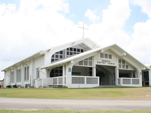
General Baptist Memorial Church
One of the island’s first Baptist churches, this church was built in 1955. It is one of the first buildings located among a row of religious institutions along one of the village’s main roads.
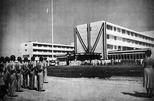
Government House
The architectural design of the governor’s official residence incorporates elements of both CHamoru and Spanish-cultural heritage. Its design was completed in 1951 by renowned architect Richard Nuetra. The structure has undergone several renovations as new governors took office and after the island was devastated by typhoons.
Maria Artero Catholic Pre-School and Kindergarten
Nestled in the middle of the village, this school is one several Catholic Schools of the Archdiocese of Agana’s school system.
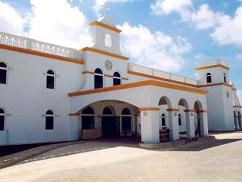
Our Lady of the Blessed Sacrament Church
The Agana Heights Catholic Church, dedicated in 1951, sits in the center of the village. It underwent a major renovation in 1995 after the structure was continually damaged by series of typhoons in the early 1980s and a powerful earthquake in 1993.
The annual village fiesta of Our Lady of the Blessed Sacrament is celebrated in November.
Scottish Rite Masonic Center
This organization was formed in 1899. In January 1955, through the combined efforts of all the Masonic Bodies in Guam the organization’s current home, a concrete block two-story structure was completed. It is the home of Charleston Lodge as well as other active Masonic bodies.
St. Fidelis Friary
In 2002, Super Typhoon Pongsona damaged the St. Fidelis Friary beyond repair. The 50 year old building was demolished and a new friary built on the same site was dedicated in June 2007.
Seventh-day Adventist Church
On 11 June 1960, the Agana Heights Seventh-day Adventist Church opened. The Agana Heights chapel was dedicated to Mrs. Ana T. Gay, an early SDA convert who donated the property for erecting a church for the Guam-Micronesia Mission.
U.S. Naval Hospital, Guam
The first US Naval Hospital on Guam was established in Hagåtña, in August 1899. The current naval hospital, built in 1953, sits on 47 acres of prime real estate in Agana Heights overlooking the capital. The facility opened in 1954 and today remains the primary medical provider for military members and their families.
Guam High School
The Department of Defense Education Activity’s islandwide high school, Guam High, is also located on this base. It was formerly located in the neighboring village of Maina in the former Commander Naval Forces Marianas headquarters, Nimitz Hill.
It is one of the three US Department of Defense (DoD) Domestic Dependent Elementary and Secondary Schools (DDESS) on Guam for children and wards of active-duty military members, and federal employees hired from the US with “return rights”. The DoD DDESS schools on Guam opened 29 September 1997.
Historical
Fort Santa Agueda
This bateria (battery), built during the administration of Spanish Governor Manuel Muro (1794 to 1802), was developed for tactical purposes. It sits atop Apugan Hill and is also commonly called Fort Apugan. It is one of the few surviving Spanish forts on Guam. It provides a commanding view of the capital village of Hagåtña, the Philippine Sea, and the sheer northern clifflines of Oka Point and Ritidian Point. The fort is also in a prime location to study the northern topography of the island with its raised limestone plateau.
Recreational
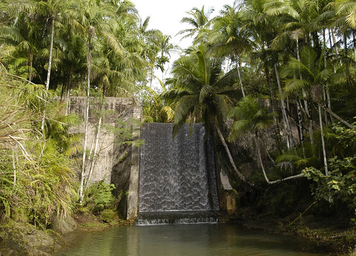
Fonte River
This river is the border of Agana Heights and Maina. A bridge across the Fonte River is the the topic of a local ghost story about the “White Lady.” It is also the location of the first dam built on Guam, the Libugon Dam. This dam was the main source of fresh water for the capital city of Hagåtña before World War II. The Fonte Valley River remains a popular swimming spot and hiking trail.
Sgt. Pedro C. Pangelinan Baseball Field
One of Guam’s first and oldest baseball fields is the Agana Heights Sgt. Pedro C. Pangelinan baseball field, named after the Guam soldier killed in action in 1968 in Vietnam. The ballpark was developed in 1949 and completed in 1951 and was the site of the first Little League Baseball game on Guam.
The Cliff
Seated along one of Agana Height’s cliff lines, The Cliff, is one Guam’s first hotels. It was established in Agana Heights in 1959. It has more recently become a business and residential condominium.
Tutujan Park
Tutujan Park, also known as “Triangle Park”, complete with water and power, was built in 2002, funded by the AB Won Pat Guam International Airport Authority. For a small fee, the park can be reserved for private functions through the Agana Heights mayor’s office.
Village mayors/commissioners
Mayors/Commissioners
- Richard B. Arroyo, Mayor, 2025-Present
- Paul M. McDonald, Mayor, 1993-2024
- Frank M. Portusach, Commissioner/Mayor, 1977-1992
- Juan E. Garcia, Commissioner, 1969-1977
- Juan L. Pangelinan, Commissioner, 1956-1969 (first elected village official)
- Anselmo Garrido, Commissioner, 1946-1953 (appointed by naval governor)
- Beldad S. Santos, Commissioner, 1944-1946 (appointed by naval governor)
Vice Mayor/Deputy Commissioner
- Juan L. Pangelinan, Deputy Commissioner, 1952-1956 (under Sinajaña)
Editor’s note: The preceding list was provided by Konsehelon Mahot Guåhan/the Mayor’s Council of Guam.
For further reading
Mayors Council of Guam. “MCOG – Mayors Council of Guam.”
Onedera, Peter R., ed. Nå’an Lugåt Siha gi ya Guåhan (Guam Place Names). Hagåtña: Chamorro Language Commission, 1988.