
Proa and Navigation

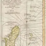
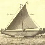
Table of Contents
Share This
Interpretive essay: Block concept
Regardless of where islands are situated throughout the vast Pacific, the physical environment—varying wind speed and direction, ocean currents, the visibility of stars, availability of birds, phosphorescence, seaweed, and other indicators of land—has played a central role in the ability of early voyagers to reach and settle thousands of islands in Oceania.
The island of Guam, the southernmost island of the Mariana Islands archipelago, which is located in western Micronesia, is not unique in this regard. Its closer proximity to Asia than islands in eastern Polynesia may account, however, for the Mariana Islands having some of the earliest settlement dates across the Pacific. The fact that Guam is part of an island archipelago may have enabled ongoing voyages between Asia and the Caroline Islands to the south as a result of the island “block” concept.
This concept is based on navigators of exploratory or return voyages of communication having the ability to enlarge their target area by looking for specific birds that fly away from islands at varying levels of distance, looking for the “loom” of land on clouds surrounding islands and/or sighting vegetation and seaweed emanating from islands. These indicators of land enabled target circles to be drawn around individual islands allowing voyagers to aim toward the larger archipelago and then look for specific islands once the archipelago was found. This is a strategy that could have been employed throughout much of the Pacific by early intentional voyagers. Stellar interpretations and notions surrounding the need to wait for westerly winds in a predominantly easterly blowing Pacific Ocean were also central to indigenous navigation and voyaging.
Contemporary seafaring strategies used by navigators from the central Caroline Islands – particularly Polowat and Satawal – may suggest strategies that were employed in early voyaging between the Caroline Islands and Guam. The strategies involved include the etak division of voyaging segments to continuously determine one’s position by aligning an out of sight reference island with a series of rising and setting stars. There is also the conceptualization of a large trigger fish stretched out over an area from Fais, an island in the western Caroline Islands, to Saipan in the northern Mariana Islands. Points along the form of this fish in association with rising and setting stars provide important, compass-like directions for successfully finding land.
CHamoru/Chamorro proas
Ethnohistorical accounts reveal that Caroline Islanders were still trading with CHamorus/Chamorros, the indigenous people of Guam, during the early Spanish occupation of the island and there is no evidence to indicate that precontact or early contact CHamorus were inferior to Carolinian voyagers and navigators. In fact, an account from the 1566 voyage of the San Gerónimo under the command of Pedro Sánchez Pericón speaks to the swiftness of CHamoru voyaging canoes and the agility of the voyagers.
The CHamoru voyaging canoe is usually referred to as a proa, apparently originating from the Portuguese word parão which itself is derived from the Malayan word para. The first European reference to the proa may have occurred when Ferdinand Magellan fortuitously came upon Guam in March 1521. Francisco Alvo’s logbook from the voyage notes that:
…many small sails approached the ship sailing so swiftly they appeared to be flying.
Another account by a Genoese pilot on Magellan’s voyage refers to the arrival of forty to fifty “parãos” after Magellan’s men had gone ashore to avenge the taking of a skiff by CHamorus, an act the Spanish interpreted as thievery and one that CHamoru viewed as reciprocity for provisions they provided the Europeans.
Subsequent references to the proa appear periodically in ship log and journal accounts, describing the proa’s lateen sail as being composed of very well-woven palm mats. Four hundred proa holding between six to twelve CHamorus each and arriving in groups of four to six surrounded Miguel López de Legazpi’s ships on January 23, 1565.
Design and demise
The account of the 1566 San Gerónimo voyage describes the proa’s outrigger as a pole outside the body of the proa, about three fathoms in length, which is fastened with lighter poles. The proa were very narrow underneath and wide above, made without any nails but stitched with cords and a few pegs, covered with red ochre instead of caulked with tar. Another account described that sections of the proa were “fastened to each other with reed lashings and a pitch made of red earth mixed with lime and coconut oil.”
Father Martin de Rada in 1565 also described a large proa shelter with four wings in the shape of a cross supported by latte stones.
Illustrative renderings of the proa from early references occur largely in association with visiting European ships, but are generally rough and distorted with few details of construction available. An eighteenth century sketch of the “flying proa” of the Mariana Islands, however, contains details that support the sleekness and swiftness that dominate historical descriptions of the proa.
In a report compiled by Father Pedro Coomans and others covering the years 1667 to 1673, two types of proa are described – the small dugout used for transportation around Guam (with some details of construction included) and a canoe used to travel around the island and to other islands. However, in contrast to the much larger proa described in 1565, Coomans maintains that these latter proa never exceeded eight to ten yards in length and could only hold one or two people.
By the end of the seventeenth century, contact and eventual settlement by Spanish colonialists and missionaries not only led to the near decimation of the CHamoru people through introduced diseases and warfare, but also, in an effort to demobilize and control the CHamoru people, led to the decline of the construction and intricate engineering details of the proa that had so fascinated early Europeans.
For further reading
Barratt, Glynn. Carolinian Contacts with the Islands of the Marianas: The European Record. Saipan: Commonwealth of the Northern Mariana Islands Division of Historic Preservation, 1988.
Goetzfridt, Nicholas J., comp. Indigenous Navigation and Voyaging in the Pacific: A Reference Guide. New York: Greenwood Press, 1992.
Lévesque, Rodrigue. History of Micronesia: A Collection of Source Documents. Vols. 1-20. Québec: Lévesque Publications, 1992-2001.
Lewis, David. “A Return Voyage Between Puluwat and Saipan Using Micronesian Navigational Techniques.” In Pacific Navigation and Voyaging. Compiled by Bed R. Finney. Wellington: Polynesian Society, 1976.
Walter, Richard. Anson’s Voyage Around the World in the Years 1740-44. Reprinted with notes by G. S. Laird Clowes, and with a new introduction by Percy G. Adams. New York: Dover Publications, 1974.