
Guam's Amazing Caves
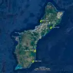
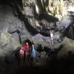
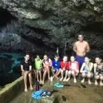
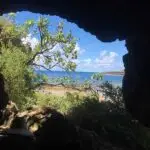
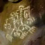
Table of Contents
Share This
How Guam formed
Guam has a wealth of geophysical and historical features through which one can experience the island and learn its history.
Perhaps none, though, is as breathtaking, amazing, and informative as its unique karst geology. In particular, its caves and how they formed.
Karst is defined as “landscape underlain by limestone which has been eroded by dissolution, producing ridges, towers, fissures, sinkholes and other characteristic landforms.”
But before there was karst, there were volcanoes. Guam began with underwater volcanic eruptions that formed the island’s base in the Paleocene, approximately 43 million years ago.
On top of that volcanic base, shallow-water corals settled and grew during different times and in different places. This happened while the growing island rose and sank on the ocean because of tectonic activity.
Over time, the coral reefs and skeletal fragments of marine organisms such as foraminifera, algae, and mollusks, secreted calcium carbonate (CaCO3). A series of changes involving contact with fresh water and air turned the skeletons and shells into limestone rock in different layers. Those layers created a record of the geologic events that created Guam – a record that today we can appreciate throughout the island.
The northern half of Guam is characterized by a 600-foot uplifted limestone plateau, made of Mariana Limestone Cliffs such as Dos Amantes Point and Barrigada Limestone, one of the oldest reef formations. The southern half, distinguished by a mountainous topography of old limestone remnants, sits on uplifted volcanic rock. It is a mix of young Malesso’ Limestone on the coastal area and older limestone inland.
Karst features
Limestone rock makes Guam a Carbonate Karst Island (CKI). And although under normal circumstances calcium carbonate does not dissolve in water, rainwater, because it is slightly acidic after mixing with CO2 from the air, does dissolve limestone.
This is how, over millions of years, stunning karst features developed as the limestone was dissolved by the slightly acidic rainwater percolating through it.
These features include flank caves, located high above sea level, sinkholes or closed depressions and pit caves on the surface ground, and sea-level caves, and springs.
Besides forming in limestone, karst forms in other soluble rocks such as dolomite and gypsum.
On the surface, the rainwater forms “epikarst,” or heavily weathered rock, as well as sinkholes at points where the water percolates underground. And as the acidic water travels down below the surface, it forms voids in small fissures to create the towering and fantastic spaces known as caves.
In caves, fresh water continues to drip from the ceiling and collects on the floor, forming springs big enough for swimming in some cases. This cave water can flow and seep toward the ocean. This discharge forms freshwater plumes that seep into coastal water. The fresh water can be seen seeping out of the ground some of island’s shores. It appears turbid as it mixes with saltwater, and feels colder than the surrounding ocean water at many beaches throughout the island.
Location of caves
Many of Guam’s karst features, caves in particular, are easily accessible and offer an amazing and unique way to learn about Guam (Figure 1).
In the northern half of the island, for example, Fai Fai Cave (Figure 2), at sea level and just a quarter mile north of Gun Beach, has large openings, making it easy to enter, and a vast void in which to easily walk around and study the geological history recorded on the limestone. Marbo Cave (Figure 3), on the eastern side of the island, has a large void with perennial fresh-water pools in which people can swim.
In the southern half, the Gadao Cave entrance (Figure 4a), also at sea level, sits at the entrance of Inalåhan Bay and is a five-minute walk from Chagamin Lago Road. It offers a glimpse into the human history of Guam, with pictographs painted onto the walls by ancient CHamoru people between 2000 BC and 1668 AD (Figure 4b). Talo’fo’fo Caves (Figure 5), approximately 300 feet above sea level just north of Talo’fo’fo Bay, is a 30-minute hike from Dandan Road. It showcases the spectacular changes Guam’s sea levels have undergone since its formation under shallow ocean waters. The incredible karst geology of Guam offers many places in which to learn and play; its caves offer residents and visitors unimaginable and astonishing landscapes in which to absorb some of the beauty of the island.
About the author

Eliana Cortés Walker is a native of Colombia, South America, and lived on Guam since 2005 with her three children and husband. She taught Spanish and was working on her master’s degree in environmental science at the University of Guam, mapping freshwater discharge into Guam’s coastal areas.
Editor’s note: This author was beginning graduate student in 2019 taking a course in scientific writing at the University of Guam. This article was assigned to provide the student with practice in communicating science to non-scientists. The student chose the topic which is related either to their thesis project or work experience. The instructor in the course is Dr. Laurie Raymundo, a UOG Marine Laboratory faculty member.
For further reading
Geological Society of America. “Geologic Timescale Chart.” August 2018.
Reagan, Mark K., and Arend Meijer. “Geology and Geochemistry of Early Arc-Volcanic Rocks from Guam.” Geological Society of America Bulletin 95, no. 6 (1984): 701-713.
Taborosi, Danko. Field Guide to Caves and Karst of Guam. Honolulu: Bess Press, 2004.
University of Guam Water and Environmental Research Institute of the Western Pacific. Karst Features of Guam, Mariana Islands. By Danko Taborosi, John W. Jenson, and John E. Mylroie. Technical Report No. 104. Mangilao: WERI, 2004.
Water and Environmental Research Institute of the Western Pacific and Island Research and Educational Initiative. “Carbonate Island Karst Model (CIKM).” Digital Atlas of Northern Guam, January 2008.
Wikipedia. “Geology of Guam.” Last modified 18 march 2021.