
Barrigada (Barigåda)
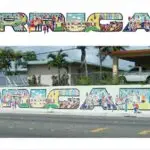
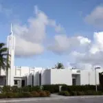
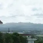
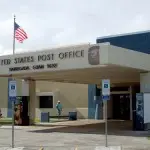
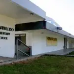
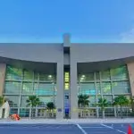
Table of Contents
Share This
Origin of village name in CHamoru
Barrigada comes from the CHamoru/Chamorro word meaning “flank” (the side of the stomach). The first written mention of the word “Barrigada” comes from Recollect Father Aniceto Ibanez del Carmen, who served on Guam for 40 years and in 1866, referred to people hunting deer in the region called “Barrigadan Tiyan.”
A 1902 map, drawn with the assistance of CHamoru priest Father Jose Palomo y Torres, shows two names for the large hill that dominates central Guam: “Mt. Tuyan or La Barrigada.” Both names fit well with the ancient CHamoru creation story of Puntan and Fu’una, which tells that the island was formed by the body of Fu’una. Both the tuyan “stomach” and the barrigada “flank” are located in the middle of the body.
Population
According to the 2010 US Census, there were 8,875 people living in Barrigada.
Village officials
June U. Blas is the mayor of Barrigada and Jessie P. Bautista is the vice mayor.
Village description
Barrigada is a land-locked village located near the center of the island on Guam’s limestone plateau. It stretches from the cliff line overlooking Harmon Industrial Park in the East to Mt. Barrigada in the north. Upscale homes have been developed on Mt. Barrigada, along an area known as Barrigada Heights; overlooking Tiyan, the interior hills of Guam, and the Philippine sea. To the south is the village of Mongmong-Toto-Maite, and to the east is the village Mangilao.
In the past, Barrigada was a popular ranching area for people from Hagåtña. Today, some parts of the village still have a rural feel attributed to the long winding roads that make their way through hills, valleys, dense vegetation, and wetlands. The village of Barrigada is now a heavily-populated residential area bordered by considerable commercial development along routes 8 (Purple Heart Memorial Highway), 10 (Vietnam Veterans Highway), and 16 (US Army Corps Drive). The recently returned former federally-designated land located in Tiyan (formerly the Naval Air Station, Guam) has become the site of some government of Guam offices, private businesses, and residential homes.
Village history
Little is known about the ancient villages that were scattered through central Guam. However, early archaeological studies on Guam found a large number of latte stones in the region now called Tiyan, which suggests that the area was well-populated. CHamorus were forced out of this region during the Spanish-CHamoru Wars of the late 17th century. However, it was not long until CHamorus started using the area for ranching and hunting, and for grazing cattle.
During the early 20th century, the village was established near the current location of P.C. Lujan school which was surrounded by scattered ranches. Some of the island’s best soil was located at Tiyan, which was ideal for corn. Early in the US Naval Era, a deep well was drilled here to attract farmers to settle. By 1924, there were enough people to warrant the construction of Barrigada’s first school. By 1940, about 875 people lived in the municipality of Barrigada, which at the time also included what is now Mangilao and Toto.
During World War II, the Japanese allowed people in Barrigada to stay in the village and several Hagåtña families moved to their Barrigada ranches during these years. However, these residents were forced to provide food for the Japanese. CHamorus were also forced to help build an airfield for the Japanese at Tiyan. When American forces arrived and secured the western beach heads in July 1944, Barrigada, and its well, were among the first inland objectives. Marines faced fierce fighting on 2 to 3 August 1944 in what came to be known as the “Battle of Barrigada.”
When the war ended, the United States military decided that the old village center would be needed for a military golf course and other military facilities. The village center was relocated to the present location of San Vicente Church where the Navy laid out new streets and lots. San Vicente Church was built in 1947. Many people who had lived in Hagåtña before the war, moved permanently to Barrigada which resulted in a 270 percent population increase between 1940 and 1946.
Points of interest
Village map
Institutions
BP Carbullido Elementary School
Barrigada Elementary School was established in 1965 and renamed Baltazar P. Carbullido Elementary School in 1966. Carbullido was a public servant, civic leader and became the islands youngest CHamoru principal at the age of 16. The school is located on Kanada-Toto Loop Road from Route 8 or Purple Heart Highway. Carbullido is home of the Ko’ko’s.
LP Untalan Middle School
Luis Palomo Untalan Middle School was first established in 1958 as Barrigada Junior High School. In 1978, it was renamed in honor of the Guam teacher. The campus sits along Route 10 or Vietnam Memorial Highway. Untalan is home of the Wildcats.
PC Lujan Elementary School
Pedro Camacho Lujan Elementary School was first established in 1961 as East Barrigada Elementary School until 1968 in honor of the Island Court clerk, Senior Judge, Guam Congressman, Senator, and Major in the Guam Militia. PC Lujan is located along Route 8 in Radio Barrigada and is the home of the Satellites.
Tiyan High School
The newest of all Guam Department of Education high schools, Tiyan High School is located at the site of the former military base in Barrigada. The school is home of the titans.
As a result of the GDOE redistricting plan, students from the areas of Barrigada, Barrigada Heights, Mongmong, Toto, Maite, Tiyan, Adelup, Anigua, Hagatna, Maina, Mogfog, Las Palmas, and Macheche comprise the new Tiyan school district.
Harvest Christian Academy
This Christian school has provided an education to Guam students for more than 40 years, starting as a small independent study program. Harvest Christian Academy began as a ministry outreach of Harvest Baptist Church in 1975. The school teaches kindergarten through grade 12.
San Roke/San Vicente Catholic Church
The San Roke/San Vicente Catholic Church sits in the middle of the village across the street from the mayor’s office and community center.
San Vicente Catholic School
Nestled in the middle of the village is San Vicente Catholic School founded in 1955 by Bishop Baumgartner, OFM Cap. The school was built on land donated by Maria Camacho and Jose Crisostomo. San Vicente has classes from pre-school to 8th grade.
AB Won Pat Guam International Airport Authority
Barrigada is home to Guam’s airport the Antonio B. Won Pat Guam International Airport Authority, the primary regional facility in Micronesia. The Guam International Air Terminal opened in 1982 and in 1986 accommodated 900,000 passengers. In January 1989, the airport was renamed in honor of Congressman Antonio B. Won Pat.
Guam Main Facility, US Post Office
Barrigada is home to the US Post Office’s Guam Main Facility, located along Route 16, or US Army Corp Drive.
Guam National Guard Readiness Facility
In 2001, the Guam National Guard opened this state-of-the-art facility that houses administrative offices, classrooms, secure storage areas for equipment and weapons and a shopping area for guard members and their dependents.
The Church of Jesus Christ of Latter-day Saints
The Church of Jesus Christ of Latter-day Saints, or the Mormon Church, in Barrigada was completed and dedicated in March 1970 after moving from its Anigua location consisting of two Quonset huts. In 1950, the first congregation was a group of servicemen and the following year both military and civilian members began meeting. The Mormon Church is located along Route 8 between Jackson and Pipeline Roads.
Recreational
Mt. Barrigada (elevation: 674 ft.)
A short drive up Mt. Barrigada offers spectacular views of Tiyan, the hills of central Guam, and the Philippine Sea. Also located along the hillside of Mt. Barrigada are upscale homes, Guam Memorial Hospital’s Skilled Nursing Facility, a Presbyterian Church and St. Dominic’s senior care facility.
Sports areas
There are softball and football fields located in Tiyan in what was formerly known as “Naval Air Station Brewer Field.” The area is a favorite walking/running area for residents.
Village mayors/commissioners
- June U. Blas, Mayor, 2013-Present
- Jessie B. Palican, Mayor, 2005-2012
- Peter S. Aguon, Mayor, 2001-2005
- Raymond S. Laguana, Commissioner/Mayor, 1977-2001
- Pedro T. Rosario, Commissioner, 1969-1977
- Jose F. Mendiola, Commissioner, 1968-1969
- Jesus S. Camacho, Commissioner, 1949-1968
- Pedro G. Cruz, Commissioner, 1946-1949
- Vicente Palomo, Commissioner, 1946-1946
- Vicente M. Flores, Commissioner, 1945-1946
- Jesus Villagomez, Commissioner, (no dates provided)
- Gregorio C. Camacho, Commissioner, (no dates provided)
- Pedro L. Cepeda Commissioner, (no dates provided)
- Jose Castro Commissioner, (no dates provided)
Vice mayors/deputy commissioners
- Jessie P. Bautista, 2013-Present
- June U. Blas, Vice Mayor, 2001-2012
- Vicente L. Guerrero, Vice Mayor, 1997-2001
- Jessie B. Palican, Assistant Commissioner/Vice Mayor, 1985-1997
- Jose F. Mendiola, Assistant Commissioner, 1981-1985
- Bernardo LG Mafnas, Assistant Commissioner, 1977-1981
- Raymond S. Laguana, Assistant Commissioner, 1969-1977
- Jose F. Mendiola, Assistant Commissioner, 1945-1969
Editor’s note: The preceding list was provided by Konsehelon Mahot Guåhan/the Mayor’s Council of Guam.
For further reading
Beaty, Janice J. Discovering Guam: A Guide to its Towns, Trails and Tenants. Tokyo: Tokyo News Service, 1967.
Hunter-Anderson, Rosalind, and Darlene Moore. A Study of Eight Post-World War II Resettlement Villages on Guam. GMF: Micronesian Archeological Research Services, 2006.
Ibañez del Carmen, Aniceto, OAR, and Francisco Resano del Corazón de Jesús, OAR. Chronicle of the Mariana Islands: Recorded in the Agaña Parish Church 1846-1899. Translated, annotated, and edited by Marjorie G. Driver and Omaira Brunal-Perry. Mangilao: Micronesian Area Research Center, University of Guam, 1998.
Mayors Council of Guam. “MCOG – Mayors Council of Guam.”
Know my island- Know my history
Traditional CHamoru place names
Some of the traditional CHamoru place names in Barrigada include Aspengao, Cañada (which means “valley” in CHamoru), Leyang (cave), Ungaguan, Lalo, Tiyan and Lusong.
Village Fiestas
Barrigada has three feast days for three patron saints: San Vicente, San Roke, and San Ramon.