Cetti

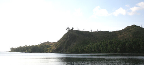


One of the most well-known scenic points of Guam is the Cetti Bay Overlook on the southwest side of the island. The surrounding foothills and Cetti Bay are part of Guamʼs Territorial Seashore Park. The overlook gives a view of the volcanic rock that comprises most of southern Guam, especially the pillow lava formations of Attelong Acho, or Black Rock, to the north. In the distance looking southward, Cocos Island, or Dano, which lies off the coast of Malesso’/Merizo village, can be seen. Because of its cultural and historical significance, Cetti is on Guamʼs and the National Register of Historic Places.
Cetti, however, is one of the hardest sites to reach by foot. It is the second bay that lies north of Humåtak/Umatac village, and is probably easiest to get to by boat when the waters are calm. To access the bay by land, one must hike along the shore north from Humåtak or the south shore from Sella Bay. Both require considerable climbing. Hiking from Humåtak requires attention to tides, as well, especially between Fouha Bay and Cetti, where there is a narrow reef backed by a hundred-foot cliff that can only be crossed at low tide. Halfway between Fouha and Cetti is a stream of fresh water that is drinkable.
Cetti is a scenic area. The south side of the bay is rocky but the north side is sandy. The surrounding area is largely grassland covered with swordgrass (sakati), as well as a ravine forest with coconut trees that hides Cetti Falls. Cetti has an abundance of seashells, and is also considered a great place for fishing and snorkeling.
Ancient village of Jati
It has been noted, at least since the 1960s, that near the north shore of the Bay is the site of an ancient Chamorro village known as Jati. This archeological site contains two latte structures, each consisting of eight stones, hidden from view by the ubiquitous swordgrass. There are also numerous Chamorro pottery sherds on the ground and remnants of Spanish era ceramics. It is likely the Cetti coastal area has been occupied for thousands of years. The Spanish later created a road system along the islandʼs western coast that ran through Cetti and connected the capital of Hagåtña with southern Humåtak.
US Navy archeologist Douglas Osborne visited the area in 1947 while on Guam to document the islandʼs archeological sites. He was mystified by Cetti, noting:
Lying near the beach, perhaps 75 yards from the water, about midway in the sweep of the bay, was a large “taza”, a latte cap made of fine coralline limestone. It had been well-shaped and smoothed. No midden was noted and the remainder of the group, if there were, it was not in evidence.
The tasa Osborne was referring to is still there today.
Osborne also observed the abundance of pottery, both Chamorro and Spanish, and was intrigued by particular sherds that possibly showed a combination of island sand tempering but with Asian ceramic influences.
Today, Cetti remains a popular destination for hiking or boating adventurers and others who want to enjoy its beach area. However, the Bay has been subject to natural erosion and some sedimentation caused by the Hågat-Humåtak road construction in the late 1980s. The government recently attempted to reforest the hillsides leading down to Cetti Bay as part of a mitigation project with an agreement between the Navy and Guamʼs Department of Agriculture. However, the plan to plant acacia trees in the area was renegotiated and will be resumed by the Navy and a private company.
Video
For further reading
Carson, Mike T., ed. “Archaeological Studies of the Latte Period.” Micronesica 42, no. 1/2 (2012): 1-79.
Beaty, Janice J. Discovering Guam: A Guide to its Towns, Trails and Tenants. Tokyo: Tokyo News Service, 1967.
Osborne, Douglas. “Archaeology on Guam: A Progress Report.” American Anthropologist 49, no. 3 (1947): 518-524.
Reinman, Fred. An Archaeological Survey and Preliminary Test Excavations on the Island of Guam, Mariana Islands, 1965-1966. Mangilao: Micronesian Area Research Center, University of Guam, 1977.
Thompson, Laura M. Archaeology of the Mariana Islands. Bernice P. Bishop Museum Bulletin, No. 100. Honolulu: Bishop Museum Press, 1932.
–––. Guam and Its People. With a Village Journal by Jesus C. Barcinas. 3rd ed. New Jersey: Princeton University Press, 1947.
US Department of the Interior National Park Service. General Report on Archeology and History of Guam. By Erik K. Reed. Sante Fe: NPS, 1952.