Badlands in Southern Guam
What is a badland?
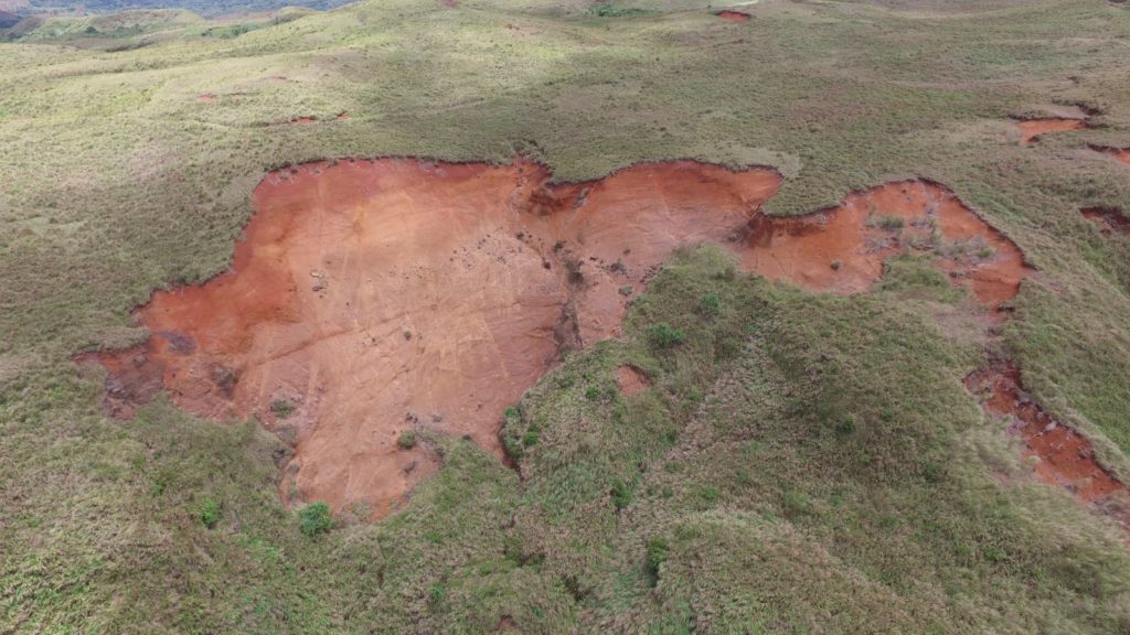
Badlands are areas of land that cannot support plant growth due to severe erosion. They are barren patches of land that are commonly reddish-brown in color, but can sometimes be tan (Figure 1).
Badlands and geology
Southern Guam is more prone to badland formation than northern Guam because of the differences in their geologic compositions (Figure 2). Northern Guam has porous, limestone bedrock that allows water to be absorbed readily during rainfall events.
It is this geologic characteristic that replenishes the Northern Guam Lens Aquifer (NGLA)—Guam’s main source of water. Also, northern Guam is primarily composed of plateaus. Any loose soil that could be picked up by runoff—water that moves over land that is not part of a stream or river—would not travel far because of the flat topography. Northern Guam’s forests are more intact which protects the underlying soil layer from washing away during heavy storms.
In contrast, southern Guam has volcanic bedrock that does not hold water as well. This means that most of the rainfall becomes runoff. And because southern Guam is mountainous, the runoff will flow downhill, traveling over more land, picking up loose sediment along its way to an area of lower elevation—usually rivers and bays (Figure 3). Furthermore, southern Guam is mostly comprised of savanna vegetation, or grasses and short shrubs, rather than forest. Because the vegetation does not provide much canopy cover, the soil is more likely to erode due to the direct impact of rainfall on the soil.


Erosion and the main causes of badland development
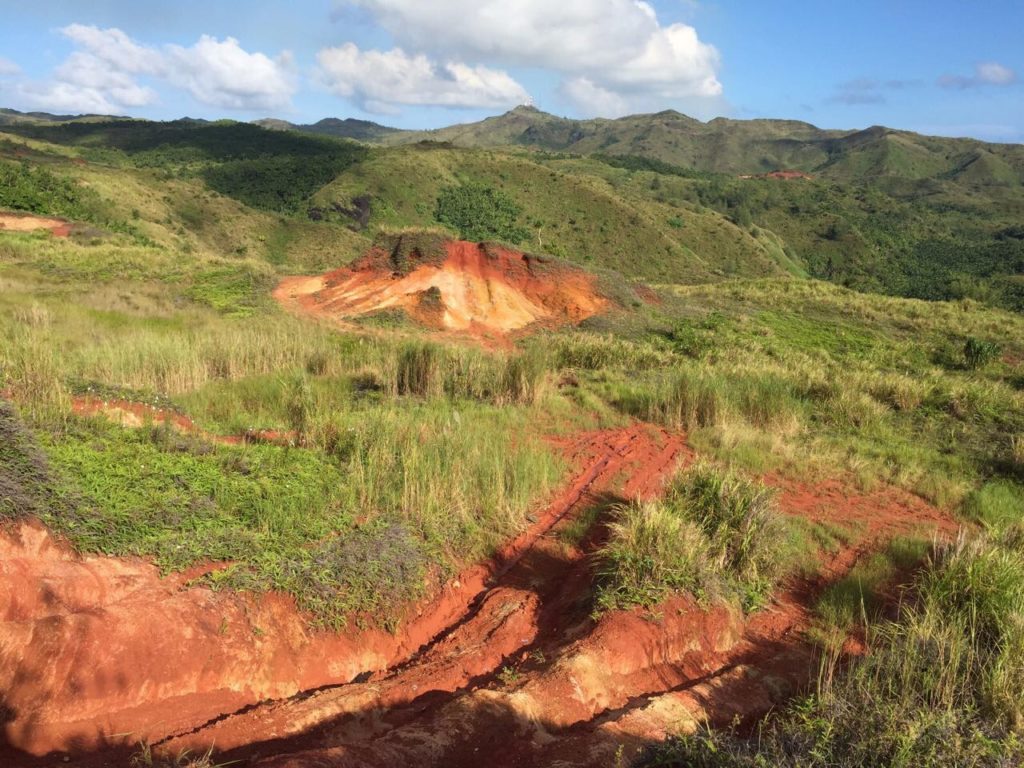
Badlands are formed by erosion, or the removal and transportation of soil and rock from its original location. Since soil can take hundreds to thousands of years to develop and be able to support plant growth naturally, preventing soil erosion is important for the land to support natural vegetation and agriculture. The main causes of erosion that lead to badland development on Guam are grassland arson fires, off-roading (Figure 4), and strong storms and typhoons.
Natural causes
Strong storms and typhoons are the only natural causes of badland development on Guam. Heavy rainfall over-saturates the thin soil layer in southern Guam’s volcanic mountains, causing landslides. One landslide can cause a large area to turn into a badland within minutes. This exposes a large portion of the underlying subsoil, typically on the steeper slopes of mountains.
In southern Guam, the subsoil is mostly saprolite—an acidic, clay-rich, nutrient-poor, highly-weathered bedrock. When the top, nutrient-rich soil layer is eroded, only the underlying saprolite is left, making it difficult for plants to naturally establish themselves there. This creates a self-perpetuating cycle since a lack of vegetation can cause badlands to develop, and badlands decrease the ability of vegetation to become established.
Human causes
Unlike storm-related landslides, off-roading and arson fires set for hunting are human causes of badland formation. Also, they are more persistent occurrences that degrade the top-soil layer overtime. Fires burn large, vegetated areas and dry out the topsoil, leaving the topsoil exposed and brittle. This increases the chances of topsoil erosion from wind and rain. Also, repeated fires can burn away the nutrients in the soil, decreasing the potential for revegetation.
Off-roading typically happens on preexisting trails in previously eroded areas, but can increase the depth and surface area of a badland patch. Off-roading trails get disturbed each time they are used, preventing soil generation and destabilizing the intact soil layers around the trails. Also, off-roading compacts the soil, so that water cannot infiltrate, which increases erosion via runoff. If arson fires and off-roading were better controlled or stopped entirely, badlands would not endure as much disturbance, and restoration efforts would be more successful.
Although badlands make up a small fraction of Guam’s total land cover, their area has grown by 8.79 percent from 1973 to 2001 (Figure 5). Also, they contribute anywhere from 2.1 to 9.5 tons per acre per year of soil erosion—more than any other land cover type on Guam. And badlands are persistent. Older badlands tend to increase in size as they continue to lose soil and weather away. Younger badlands have a better chance to revegetate because good soil sometimes get caught in the downhill edges of a badland patch instead of completely washing away.

The impacts of badlands on the environment
Badlands are a concern because they are the biggest source of sedimentation in Guam’s rivers and bays. Sedimentation in Guam’s rivers causes water outages in southern Guam during heavy rains because the Ugum Water Treatment Facility cannot strain out the high sediment load. Sedimentation also kills corals. When the sediment enters the bays from the rivers, it blocks the sunlight the coral needs to produce food and suffocates when a large amount of sediment settles on them (Figure 6). These stresses on corals can kill corals and reduce their growth, their ability to reproduce, and the recruitment of juvenile corals. This is why many coastal reefs in southern Guam have been greatly reduced in size over the past few decades.

Having healthy coral reefs is very important for tropical islands like Guam. Firstly, coral reefs provide habitat for fish, some of which are common catches by our local fishermen, i.e. ti’ao (baby goat fish) and mañahak (baby rabbit fish). Secondly, coral reefs serve as barriers for our coasts by absorbing the impact from waves and storms. Lastly, coral reefs attract tourists from all over the world interested in snorkeling and diving, generating revenue from external sources. Without our reefs, we risk losing our fisheries, protection from coastal erosion, and revenue from tourism.
Historical accounts of badlands and the origin of Guam’s savannas
The first written description of badlands is from Antonio de Pineda, a naturalist who visited Guam in 1792. In his book, Guam Diary of Naturalist Antonia De Pineda y Ramirez February 1792, De Pineda described exposed red soil patches that were a common feature in the central region of Guam. Although the extent of the red patches was not measured, this confirms that badlands have existed on Guam at least since then.
Supposedly, the vegetation in southern Guam changed considerably with the arrival of the first CHamorus. The pollen record dating back over 9,000 years shows that southern Guam was mostly covered in dense forest before the arrival of humans 4,000 years ago. The pollen records also show that when the forests declined, grasses increased and so did the evidence of fires. This suggests that the savanna landscape was a result of the first people repeatedly burning areas. Since badlands normally occur in Guam’s southern savannas, these environmental changes could have started their development.
Research on Guam’s badlands
Badlands are an ongoing subject of research because of the impacts they are having on our environment. One study by Wen et al. (2009) converted satellite imagery from 1973 and 2001 into land cover maps. They were able to see the changes in land cover in southern Guam over 30 years. The land cover types they looked at include: grassland, forest, urban, barren, burned, and water According to this study, barren land develops in grassland more than in forested areas.
Currently, various institutions and agencies, including the University of Guam Water and Environmental Research Institute, the UOG Center for Island Sustainability, Guam Division of Forestry, Guam Division of Aquatic and Wildlife Resources, and National Park Service, are working on finding solutions to badlands on Guam. One approach is the planting of acacia trees by Guam Division of Forestry. Acacia trees are used because they stabilize the soil and add nitrogen, a primary nutrient for plants, into the soil.
One study has begun to document the effectiveness of acacias in preventing erosion in badland areas. Shelton (2015) planted acacia trees and installed sediment filter socks in the La Sa Fua watershed and documented the amount of sediment collected over 21 months. Sediment filter socks are mulch-filled, mesh stockings that catch sediment during storms. This study recommended that, in order to reduce the sedimentation in Fouha Bay to an acceptable level for coral health, 19 km of sediment filter socks and 11,000 acacia trees should be installed in a 0.05 km2 area.
Since researchers know with great confidence the causes of badlands and their impacts on the environment, the next steps are public education, badland prevention, and restoration of existing badlands. Coral reefs are already stressed by climate change, and sedimentation from human activities further worsens their health. As Pacific Islanders, we rely on healthy coral reefs to provide food, coastal protection, recreational uses, and attractions for tourists. Living on an island also means we have limited land. If our topsoil continues to erode, agriculture and environmental health will also decline. By restoring existing badlands and preventing badland development from human activities, our island will be more prosperous for future generations.
About the author
Lauren Swaddell was a Master’s of Science candidate in Environmental Science at the University of Guam. She worked on UOG Sea Grant’s Guam Restoration of Watersheds (GROW) project in collaboration with UOG Center for Island Sustainability. Her main focus was determining the most appropriate native savanna species to revegetate badlands in southern Guam.
Editor’s note: This author was a beginning graduate student in 2017 taking a course in scientific writing at the University of Guam. This article was assigned to provide the student with practice in communicating science to non-scientists. The student chose the topic which is related either to their thesis project or work experience. The instructor in the course is Dr. Laurie Raymundo, a UOG Marine Laboratory faculty member.
For further reading
Athens, J. Stephen, and Jerome V. Ward. “Holocene Vegetation, Savanna Origins and Human Settlement of Guam.” Records of the Australian Museum, Supplement 29, no. 1 (2004): 15-30.
Humåtak Project. “Humåtak Project Home.” 2012.
Shelton, Austin. “Building Island Resilience against Climate Change: Integrating Science into a Community-Based Initiative Reviving Watersheds, Coral Reefs, and Fisheries in Guam.” PhD diss., University of Hawai`i at Manoa, 2015.
University of Guam Marine Laboratory. The Economic Value of Guam’s Coral Reefs. By Pieter van Beukering, Wolfgang Haider, Margo Longland, Herman Cesar, Joel Sablan, Sonia Shjegstad, Ben Beardmore, Yi Liu, and Grace Omega Garces. Technical Report No. 116. Mangilao: ML, 2007.
University of Guam Water and Environmental Research Institute of the Western Pacific. Watershed Land Cover Change in Guam. By Yuming Wen, Shahram Khosrowpanah, and Leroy F. Heitz. Technical Report 124. Mangilao: WERI, 2009.
University of Guam Water and Environmental Research Institute of the Western Pacific. Spatio-Temporal Dynamics of Badlands in Southern Guam: A Case Study of Selected Sites. By Maria Kottermair, Mohammed H. Golabi, Shahram Khosrowpanah, and Yuming Wen. Technical Report No. 133. Mangilao: WERI, 2011.
US Department of Agriculture Natural Resources Conservation Service. Utilization of Compost Filter Socks. By Ray Archuleta and Britt Faucette. Agronomy Technical Note No. 4. Washington, DC: NRCS, 2011.
US Department of Agriculture Soil Conservation Service. A Soil Survey of the Territory of Guam. By Fred J. Young. Washington, DC: NRCS, 1988.