Fort San Jose


Defensive position in Humåtak
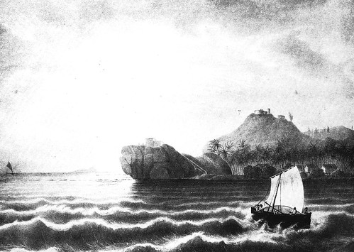
Fort San Jose, built about 1805, was the third of four Spanish fortifications built in the southern village of Humåtak/Umatac. The fort was constructed atop a hill located on the northern side of Humåtak Bay. From this location, the fort had a sweeping view of the coastline and was well positioned to defend the ships that anchored off the bay.
During the second half of the sixteenth century, Humåtak Bay became an important safe-haven and supply station for Spanish galleons sailing across the Pacific Ocean during the Acapulco-Manila galleon trade (1565 – 1815). However, these galleons, loaded with treasures, also caught the attention of Spain’s enemies. The first English privateer to reach Guam’s waters was Thomas Cavendish in 1588, aboard the Desire. Cavendish replenished his ship with food and water supplied by CHamorus in flying proas (outrigger sailing canoes) that came to meet the ship, but he did not anchor. Later, the ill-tempered Cavendish ordered his men to spray the proas with musket fire as the islanders tried to follow his departing vessel. With the steady increase of non-Spanish ships sailing through the Pacific, fortification of the island became imperative.
From 1680 to 1810, four Spanish fortifications were built to protect the anchorage at Humåtak Bay. In 1680, a battery named Nuestra Señora del Carmen was assembled on the shoreline of the bay to protect the mouth of the Salupat River where ships filled their water barrels. By 1742, British Commodore George Anson reported on the existence of Fort Santo Angel, on the northern tip of the bay. This fort was later modified in 1756. In 1805, Fort San Jose was constructed on a hill above and to the north of Santo Angel. And, by 1810, the last Humåtak fortification, Fort Nuestra Señora de la Soledåd, was constructed on the southern tip of the bay.
Fort San Jose was built during the administration of Governor Vicente Blanco (1802-1806). Its construction was instigated by the 1803 inspection of its predecessor, Fort Santo Angel, by Captain Ignatio Martinez. It was determined that Santo Angel was in poor condition as a result of years of pounding surf wearing away its foundation.
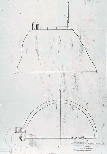
Upon this inspection, Governor Blanco ordered Fort San Jose to be constructed on the hill above the damaged Fort Santo Angel in order to strengthen the defense of the bay. In an 1805 document, Governor Blanco identified the fort by name and described that it housed five eight-caliber cannons, one six-caliber cannon, a sentry-box, and a powder magazine.
The fort was built in an oval shape, approximately forty varas, or 112 feet, above sea level. Its walls were constructed of mampostería; stone and mortar. The esplanade was level and protected with a knee-high parapet, over which the cannons were positioned to fire.
The condition of the fort steadily deteriorated over the years. The Mexican Revolution facilitated the end of the galleon trade. In 1815, the last Cavite ship returned to the Philippines, officially bringing an end to an era that lasted for 250 years. Spain no longer had the means to maintain Guam’s fortifications. In 1818, Governor José de Medinilla y Pineda reported that the construction of San Jose was poorly planned and the ground it was situated on had sunk. He also observed that the fort was not situated in an area where it could protect the bay’s channel entrance. By 1853, Governor Felipe de la Corte declared the fort to be in total ruins. Today, little remains to distinguish the area of the fort.
For further reading
Beaty, Janice J. Discovering Guam: A Guide to its Towns, Trails and Tenants. Tokyo: Tokyo News Service, 1967.
Degadillo, Yolanda, Thomas B. McGrath, SJ, and Felicia Plaza, MMB. Spanish Forts of Guam. MARC Publications Series 7. Mangilao: Richard F. Taitano Micronesian Area Research Center, University of Guam, 1979.
Driver, Marjorie G., and Omaira Brunal-Perry. Architectural Sketches of the Spanish Era Forts of Guam: From the Holdings of the Servicio Historico Militar, Madrid. MARC Educational Series no. 17. Mangilao: Richard F. Taitano Micronesian Area Research Center, University of Guam, 1994.
Guam Department of Parks and Recreation. “Guam State Historic Preservation Office.”
Lévesque, Rodrigue. History of Micronesia: A Collection of Source Documents. Vol. 18, Russian Expeditions, 1808-1827. Québec: Lévesque Publications, 2001.