Tsunami and Earthquake History and Potential for Guam


Marianas a part of the Ring of Fire
Since the devastating earthquake and tsunami that ravaged Japan’s coastline in March 2011 and sent thousands of Guam residents looking for higher ground, questions about the vulnerability of Guam and the Northern Mariana Islands to an equally dangerous tsunami have been raised.
Guam is no stranger to the effects of some of nature’s most destructive forces, including earthquakes and typhoons, but tsunamis hit only rarely.
What is a tsunami?
In simplest terms, a tsunami is a large, extensive, open ocean wave or series of waves caused by an earthquake or an underwater landslide. Tsunamis may also be caused by volcanic eruptions, or by large chunks of ice breaking away from a glacier, or by other phenomena that cause large displacements of ocean water.
The word tsunami originates from Japan, where it means, “harbor wave.” Japan is a country made up of many islands and the coastline is dotted by numerous harbors that, historically, are particularly vulnerable to earthquake-generated tsunamis. As evident in the recent Japan earthquake in 2011, the 2004 Indian Ocean Earthquake in Sumatra, Indonesia, and the 2009 earthquake in American Samoa, tsunamis can be extremely destructive in coastal regions.
Although sometimes used interchangeably, tsunamis should not be confused with tidal waves. Tsunamis are also different from surface tides and tidal surges, although these waves may have similarly destructive effects on coastlines. The term tidal wave is used in reference to ocean waves caused by the gravitational pull between the moon and the earth. Surface tides are caused by wind blowing across the surface of a large open body of water, such as an ocean, lake or river. Surface tides range from small ripples, to large swells. Tidal surges are particularly destructive waves caused by strong winds that are generated by typhoons and hurricanes. When tidal surges break on shore or over land they can cause significant damage to property and endanger coastlines.
Earthquakes and tsunamis
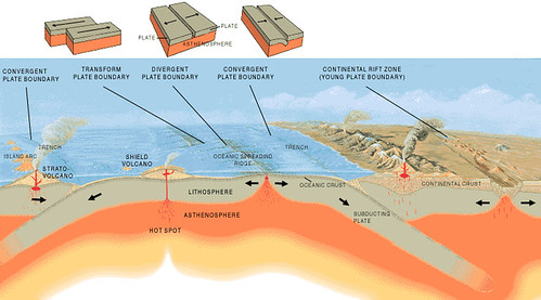
Tsunamis are commonly caused by earthquakes. The hard rock surface of the earth, or the crust, is made up of plates that move on top of a liquid rock layer underneath, or the mantle. This is the idea behind the theory of plate tectonics. When two plates come in contact with each other, they may rub against each other laterally or side by side. This site of contact may be apparent on the earth’s crust as a fault line, like the San Andreas Fault that runs along the length of California.
Sometimes the earth’s tectonic plates spread apart, like the mid-Atlantic Ridge. Or, one plate may sink beneath the other. This is called subduction, and an area where this occurs is known as a subduction zone. As one plate sinks, the other plate is lifted up. Mountain ranges, islands and deep ocean trenches can form in subduction zones. For example, the Mariana Islands lie on the edge of the zone where the Pacific Plate sinks beneath the Philippine Plate, forming the Marianas Trench, the lowest elevation on the earth’s surface. Around 43 million years ago, the release of magma from volcanic activity in this area resulted in the formation of Guam, the oldest of the Mariana Islands chain.
Though not always detected by humans, the earth’s plates are continuously moving, and they experience a considerable strain at these points of contact. When the strain becomes too great, they move in a way that can be detected at the surface as an earthquake.
Scientists measure the strength of an earthquake using an instrument called a seismograph. The strength or magnitude of an earthquake is designated with a numeric ranking on the Richter Scale, which goes from 0-10. Typically, stronger earthquakes that can be felt and cause damage measure between 5.5 and 8.9 on the scale.
The earthquake that caused the March 2011 Japan tsunami measured 9.0 on the scale. The memorable earthquake that struck Guam in August 1993 measured 8.1, although some sources recorded it at 7.9. The earthquake in American Samoa that caused a tsunami in September 2009 also measured 8.1. American Samoa, Japan and Guam experience frequent earthquakes. This is because they are located in a region geologists commonly refer to as the Ring of Fire.
The Ring of Fire is an area in the Pacific Ocean where the movement of the earth’s plates causes frequent earthquakes and volcanic activity. The ring extends along the edges of the large Pacific plate, from New Zealand, through Indonesia, past the Mariana Islands and Japan, and along the Aleutian Islands in Alaska. The ring continues further along the whole west coast of the North American continent, Central America and South America to the southernmost point in Chile. These coastal areas are particularly vulnerable to the effects of tsunamis even if the epicenter of an earthquake is located thousands of miles away.
When an earthquake occurs in the ocean, the energy released from the movement of the plates on the earth’s crust can generate a series of waves on the ocean surface. The waves radiate outward from the center of the quake (or epicenter). The effect resembles the rippling waves caused by throwing a stone in a still pond. Offshore, tsunami waves have a short height (or amplitude), but a very long wavelength (or the distance between waves).
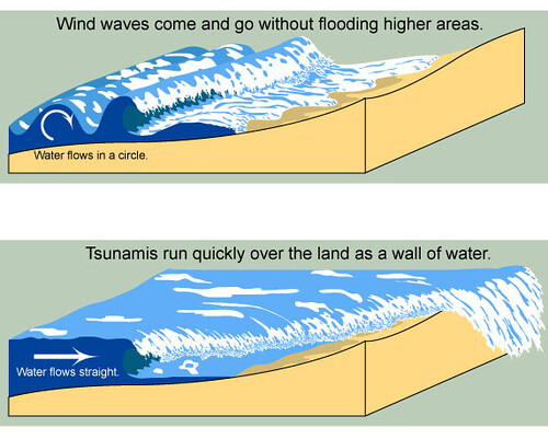
Under normal conditions, oceanic wavelengths are about 30 to 40 meters, but a tsunami may have wavelengths several hundred kilometers apart. In deep water, the effect of a tsunami is hardly detectable because of this huge wavelength. However, as a tsunami approaches a shoreline where the waters are shallow, the waves slow down. This causes the wavelength to shorten and the wave height to grow enormously. The destructive force of a tsunami, though, occurs not only when the wave crashes into the shoreline at high speed, but also by the receding of the water as it goes back towards the ocean, dragging buildings, vehicles, trees and other debris out to sea.
According to geologists, a tsunami may feature multiple waves, and sometimes it may take several hours for the waves to travel thousands of miles across open water. In fact, not all earthquakes will produce tsunamis that actually make it to a shoreline. Whether a destructive tsunami is generated after an underwater earthquake is difficult to detect.
Sometimes, an indicator of an impending tsunami is the drawback of water on the shore, exposing fish, coral and other features that would normally be under water. When such a drawback of the ocean occurs, it is a good idea for people to head inland or move to higher ground. Today, sophisticated instruments are used to monitor changes in sea level, especially after an earthquake, and to alert coastal zones of impending danger from destructive tsunamis. Guam receives its information from the Pacific Tsunami Warning Center, which has detectors on buoys located throughout the Pacific Ocean. The PTWC is based in Honolulu, Hawai’i, and operated by the National Oceanic and Atmospheric Administration, an agency of the United States government.
By virtue of the island’s location along the Ring of Fire, it is not surprising that Guam is the site of regular earthquake activity. In fact, earthquakes occur every day on Guam, but the majority of them are imperceptible without a seismograph. Occasional destructive force earthquakes occur every few years, as evidenced in the landscape and geological record, as well as in historic accounts.
The volcanic activity in the region causes much of the earthquake activity on Guam. In addition, there are thousands of fault lines that zigzag across the island, resulting from the collision (and subduction) of the Pacific plate and the Marianas plate. A major fault line divides the island geologically between the limestone plateau of the north, and the mountainous volcanic region in the south. Named the Adelup-Pago Point fault, the fault line runs roughly between Pago Bay on the east coast of the island, to Asan on the west—near the location of the Governor’s Complex in Adelup.
The Tamuning-Yigo fault moves south-southwest from Mt. Santa Rosa in Yigo, along Latte Heights, past the airport and to the boundary between Tamuning and East Agana. Further south, the Cabras Fault runs from Facpi Point (which lies about five kilometers north of Humåtak) and moves northeast along the west coast toward Piti Bay. In addition, a number of smaller fault lines run along the valleys of southern Guam. It is no wonder, then, that Guam should experience so many earthquakes during the year.
Historic accounts of Guam’s seismic events
Accounts from the Spanish Era and the early American period provide an interesting record of historic earthquake activity on Guam, and at least one report of a devastating tsunami. At least four earthquakes of magnitude 7.0 or greater on the Richter scale occurred between 1849 and 1911. Unconfirmed reports of earthquakes in the late 1700s include events in 1767, 1769, 1779 or 1799. Major earthquakes have been reported, in 1809, 1810, 1822, 1825, 1834, 1837, 1849, 1892, 1901 and 1909.
Guam has had 3 tsunamis large enough to cause damage
A 2002 study by geologists James Lander and Lowell Whiteside of the University of Colorado and Paul Hattori from the US Geological Survey Guam Geophysical Observatory examined the history of tsunami events on Guam over the last 200 years. Based on historic accounts, they determined that Guam has had only three tsunamis that were large enough to cause damage—in 1849, 1892 and, most recently, in 1993. Another two to six events may have been recorded, but are not verifiable as true tsunamis. Waves originating from further away include those produced during the 1952 Kamatchka, Russia, and the 1960 Chile earthquakes.
One of the earliest records of an earthquake and destructive wave activity on Guam was a description by Louis Claude de Freycinet, a French explorer who traveled to the Marianas in 1819. He wrote:
An earthquake made itself felt, on May 7 at 1:30 pm. With surprise and fright together, we saw the earth itself undulating form north to south for a period of perhaps thirty seconds. The residence cracked in every part, tiles came hurtling down and one would have thought that the entire structure was about to collapse around our heads. All inhabitants fled, some into the streets, others into gardens. No further disaster befell us all, however. Passed on from the land to the sea, the upheaval was felt aboard in the guise of violent shakes.
In late 1837 a series of strong earthquakes coincided with strong storm causing major flooding, landslides and damage. Four of the Caroline Islands were submerged, forcing residents to migrate to Guam and eventually settle in Saipan.
Twelve years later, another devastating tremor struck the island. A graphic description of the earthquake and tsunami of 1849 was presented in a letter by then-Guam governor Pablo Pérez. The island was in the wake of a flu epidemic that had taken many lives. In his letter, he recounted not only the earthquake and aftershocks, but also the extensive devastation caused by ground rupture and a tsunami that killed one woman and injured her niece:
On 25 January last, at 2:49 in the afternoon, there was a great temblor, or earthquake, on this island that lasted one and a half minutes…The shocks continued all afternoon at very short intervals of approximately four, six and eight minutes. At eleven o’clock that night, they ceased until 2:30 in the morning, then continued on the following days…In addition to the repeated shocks, we felt something like a subterranean boiling, and we thought we were atop a volcano that would send us flying though space when it exploded. After nine days, the continual boiling-like rumbling stopped, but the tremors continued…A pilot and several seamen who were on the beach reported and swore they had seen two flashes of fire leap from the surf as it crashed on the reef off this port. The flashes were preceded by two sharp cannon-like reports.
The earth opened in several places. Large fissures appeared in the center of the city; fourteen walls opened, gushing water, sand and fish… That afternoon, in my presence, the wells were sounded with a rod and found to have a depth of from one to six varas (one varas is 33 inches). On the following day I had them filled to obliterate the horrible sight, also because four of them were beneath houses, causing some to tumble, others to tilt. Many boulders have tumbled along the shore and from the interior hillsides. The shaking was so severe that bottles and other small receptacles on floors and shelves fell.
The fissures were even more frightening because of the release of fumes.
The sole tragedy involving loss of life was the death of a woman, who was at her ranch near the beach and was swept away by one of three tidal waves. The two-year old niece who was with her received bruises on her face when the sea carried her forty yards before depositing her among the rocks.
The woman’s name was reported as Josefa Lujan, from the village of Hagåtña. Lujan was walking from her låncho in Talo’fo’fo toward Inalåhan, when she was swept away by a giant wave which washed over the road. Her body was never recovered, although her niece survived with minor injuries.
The vertical run-up of the tsunami was about 11.5 feet (3.5 meters). Governor Perez described many structures being damaged, including the tile roofs on several administrative buildings, as well as the Humåtak church. The church in Hagåtña lost its bell tower, while the boys’ school, the Colegio de San Juan de Letran was almost completely destroyed. So far-reaching were the effects that, in fact, the captain of a whaling frigate informed the Governor that he felt the quake a thousand miles east of Guam.
In the Caroline Islands, it was reported that some of the atolls were actually submerged for several hours by the tsunami caused by the earthquake. Several survivors from the islands of Satawal and Lamotrek managed to escape, migrating to Saipan in the northern Marianas some two months later.
Father Aniceto Ibáñez del Carmen, an Augustinian priest and parish chronicler living on Guam in the mid-1800s, also wrote a description of the 1849 earthquake and tsunami, similar to Governor Perez’s account. In addition to recounting general happenings in the island during his stay, he also chronicled a number of earthquakes that occurred. Ibáñez, for example, noted that occasional tremors took place in 1855, which, along with illnesses and typhoons, made for a memorable year. He was more descriptive regarding an earthquake in 1862. Ibáñez wrote:
On 1 July 1862 at 7:48 in the morning…a small though quite perceptible quaking was felt—up and down—and then a strong oscillating movement from North to South. The force of the earthquake was such that practically all the thatched roofs collapsed. This tremor or earthquake lasted between forty-five and fifty seconds, more or less.
Ibáñez also mentioned two “terribly strong” earthquakes striking on 13 May 1870 around 3:27 pm. That same year on June 14th, another strong earthquake was felt at 2:55 am.
In May 1892 a tsunami in Hagåtña was recorded from an earthquake that struck Guam, although no measurements of its height or damage were available. Landers et al (2002), however, state that a drop in water level was reported and damage occurred in the old San Antonio district (near the current CHamoru Village).
Strong destructive quakes also were recorded in the early years in the 20th century. On 22 September 1902, a tremendous earthquake struck the island at 11:24 in the morning. The Hagåtña church lost its bell tower and one of the church walls collapsed. Bridges on the Hagåtña -Piti road caved in, along with many coral masonry (mampostería) structures. The wooden Humåtak church of San Dioniso was destroyed, as it was earlier in the 1849 quake. One child was killed by falling debris. Tremors continued for an entire week, and public schools were closed for nearly two years.
The damage was extensive enough to cause US naval governor Seaton Schroeder to issue an order implementing new construction standards to make buildings safer. Although the Hagåtña church was rebuilt under the new standards, it was destroyed again following an earthquake in 1909. This quake, centered on Guam, as well as one recorded in February 1903, which occurred in the Philippines, generated tsunamis, although no information was available about the vertical run-up for each event.
Other small tsunami events may have occurred throughout the 20th century from earthquakes generated away from the Mariana Islands. A 2008 report from the National Geophysical Data Center mentions that in March 1952 an earthquake in Hokkaido, Japan, produced a tsunami in Apra Harbor with a vertical slope of 0.03 foot (0.1 meter); eight months later an earthquake in Kamchaka, Russia, generated a similar sized tsunami that made it to Guam. An earthquake in the Aleutian Islands off of Alaska caused a 0.03 foot tsunami in March 1957, and a May 1960 Chilean earthquake produced a 0.07 foot (0.2 meter) tsunami. Two more quakes, one off the Kuril Islands, Russia, in October 1963, and another off the Alaskan peninsula in March 1964, each produced a 0.03 foot (0.1 meter) tsunami on Guam.
Other notable tremors include a 6.7 earthquake that occurred in October 1936, originating approximately 80 miles southwest of Guam. More than 25 aftershocks were reported, exacerbating the damage to plaster walls and tile roofs by the original quake. A 6.2 temblor was recorded in the same place as the 1936 earthquake in September 1970, while a 6.2 earthquake occurred in November 1975, causing almost $1,000,000 in damage. Another 5.2 earthquake struck in January 1978 near the east coast of the island with considerable damage. No tsunamis, however, were recorded with any of these occurrences.
Strongest quake was in 1993
The strongest recorded earthquake struck in August 1993. It was measured at a magnitude of 8 and lasted a full minute. Although no deaths were reported, 71 people were injured and several hotels suffered extensive damage. The southern part of the island experienced numerous landslides and rockslides, and more than $250 million in structural and property damage was sustained to roads, homes, buildings and cars.
Another seismic phenomenon as a result of earthquakes is liquefaction. Liquefaction occurs when water saturated sediments (such as sand or soil in a manmade landfill) lose strength and stability and act like a liquid. During the August 1993 earthquake liquefaction occurred at the commercial port in Apra Harbor and in downtown Hagåtña causing large cracks and fissures in the ground.
Interestingly, there were reports of individuals who witnessed unusual wave activity and a minor tsunami in Pago Bay. In the Pacific Daily News Sunday edition Tony Guerrero recounted walking to his parked truck and noticing the calm waters about 15 yards beyond the normal water line. As he tried to enter his vehicle, the waves came in and covered his legs. A second wave rising as high as his windshield swept him and his truck about 30 feet from the shore, making him unable to open his door until the water receded.
Risk of tsunamis on Guam
Because of the recent devastating earthquakes and tsunamis in Japan, Samoa and Indonesia, the question of Guam’s risk of tsunamis has been raised. The notion that Guam is largely protected by the deep waters of the Marianas Trench and the reefs surrounding the islands is commonly accepted, although this idea has been refuted by some geophysicists for a number of reasons.
According to Gerard Fryer, a geophysicist from the Pacific Tsunami Warning Center, in an interview with the Pacific Daily News shortly after the Japanese tsunami he stated that the depth of the trench gives islanders a false sense of security. The deep waters along Japan’s east coast, for example, did little to protect that country from the devastating tsunami. In addition, he stated that while the presence of strong, deeply sloping fringing reefs do provide some protection by causing tsunami waves to reflect off them and dissipating their energy before they can get to the shore, gaps in the reef still may provide an opening for destructive waves to come through and cause coastal damage. Furthermore, the wavelengths of tsunamis are usually very long; if a large enough tsunami were to strike Guam the waves potentially can wrap around the edges of the island, causing flooding on exposed shorelines.
The authors of the 2002 Lander et al. report also considered the risk of destructive tsunamis on Guam. They asserted that a locally generated tsunami would most likely occur on the east coast of the island, where the Marianas Trench is situated and the known origin of many earthquakes felt on Guam. Additionally, a tsunami that originated further south could possibly impact both the east and west coasts of the island with the wrap-around effect.
However, the Lander report argues that because of the age and relatively slow rate of subduction of the Pacific plate underneath the Philippine plate, there should be fewer earthquakes and therefore, less chance of tsunami. This has been the case for most of the Marianas archipelago. Guam, though, is situated along the trench where, nearby, there are differences in depth and heights of the subducting plates. It seems in areas where the waters are shallower, there is an increased amount of seismic activity, which may account for some of the earthquakes felt on Guam.
In the models Lander et al cite, there are other factors to consider—the steepness of the fault lines, for example, or vertical vs. horizontal movements of the plates, as well as the occurrence of secondary movements from liquefaction and landslides during a seismic event. Nevertheless, they assert, the incidence of destructive tsunamis is rare because of the extreme depth of the trench and the slow rate of subduction, and that the two significant tsunamis of 1849 and 1993 were the result of quakes that centered on the more shallow dipping areas of the plates. In these cases, the earthquakes occurred on the eastern side of the island, producing waves that impacted Guam’s east coast.
Although the likelihood of tsunamis is low, if they do occur, it is more likely they will occur on the east coast of Guam. Southern Guam may be vulnerable, but more heavily populated areas in the central, western parts of the island are less likely to be negatively impacted by tsunamis.
Cultural responses
In the course of the long history of human habitation of the Mariana Islands, the people who live in this part of the world have adapted to survive a host of potentially hazardous forces of nature. Along with the physical challenge of surviving earthquakes, typhoons and tsunamis they dealt with the human need to understand and give some kind of cultural meaning to these phenomena.
The ancient CHamorus, for example, explained wind, waves and fire as part of the activities of the spirit-god Chaifi. Prayers to ancestral and natural spirits were invoked to ensure success in human projects of navigation, farming and fishing, as well as protection from the earth’s destructive forces. When Christianity was introduced, the power to control the forces of nature was placed in the hands of God, and the Virgin Mary became the great intercessor to turn to for protection and aid.
American anthropologist Laura Thompson, who studied CHamoru culture on Guam in the late 1930s, documented two solemn novenas, a type of Catholic prayer devotion and ritual that takes place over the course of nine consecutive days, specifically for protection from earthquakes. According to her informants, the Nobenan I Promesa pat I Nobenan I Linao originated in fulfillment of promises made by the people of Guam after a destructive earthquake that occurred in April 1858 and the 1902 temblor that destroyed the cathedral in Hagåtña. Although most people on Guam understand and accept plate tectonics theory, it is not uncommon for many to return to rituals of prayer when natural disasters occur.
Typhoon and earthquake connection under study
Interestingly, the Lander report also considered the seemingly apparent connection of large earthquakes and typhoon activity on Guam. For example, the August 1993 earthquake was closely associated with Typhoon Steve. Perhaps, the authors suggest, the winds generated from typhoons, along with appropriate high stresses in earthquake regions, can trigger an earthquake. Or, pressure changes from the extreme low pressures associated with typhoons can hypothetically cause the land to rise under a reduced load and result in an earthquake.
The model for this seems to work for an earthquake that occurs under land, but for an earthquake under the ocean, there may be another mechanism involved. In the case of the August 1993 quake, the eye of Typhoon Steve, an area of relative calm, passed 80 km north of the island, with winds pushing Guam and the Philippine plate to the northwest. This movement, the Lander studies asserts, may have reduced the friction between the Pacific and Philippine plates which resulted in the strong earthquake. Furthermore, in a look at the history of earthquakes and typhoons on Guam, Lander et al observed that far more earthquakes occur within one day of the arrival of typhoons, than any other day in the 10 days before or 10 days after a typhoon has passed Guam at its nearest approach to the island.
Regardless of the risk of tsunamis on Guam, the Government of Guam has tried to arrange for a tsunami preparedness program and warning system which includes signage and public announcements, but no sirens are found in other tsunami-prone areas. Although there are criticisms of the warning system currently in place, in an island that has experienced periodic natural disasters including typhoons and earthquakes, residents are always at a level of preparedness that exceeds other locales vulnerable to such phenomena.
For further reading
Farrell, Don A. History of the Mariana Islands to Partition. Saipan: Commonwealth of the Northern Mariana Islands Public School System, 2011.
Freycinet, Louis Claude Desaulses de. Uranie et Physicienne Voyage. Paris: Chez Pillet Aîné, 1825.
Martratt, Joyce I. “With all the recent earthquakes, has Guam ever experienced tsunami?” Andersen Air Force Base News, 1 October 2007.
Repetti, William C., SJ. “Extracts from Catalogue of Earthquakes Felt in Guam, 1825-1938.” Guam Recorder 17, no. 1 (1940): 25-26, 38-39.
Rogers, Robert. Destiny’s Landfall: A History of Guam. Honolulu: University of Hawai`i Press, 1995.
Tolentino, Dominica. “Nobena: Novena (Catholic Devotional Prayers).” In Guampedia. Last modified 19 May 2021.
US Department of the Navy and Joint Guam Program Office. “Geological and Soil Resources.” In Final Environmental Impact Statement Guam and CNMI Military Relocation. Pearl Harbor: NAVFAC, 2010.